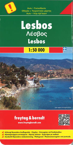
Lesbos, Greece by Freytag-Berndt und Artaria
Explore Lesbos, an island in the north east of Greece, with this Freytag & Berndt single-sided road and leisure map. The map will allow you to travel independently, and plan your journey well.
The map also features full colour photographs of some of the scenery to be found on Lesbos, as well as an inset showing Lesboss position within the nation of Greece. An inset is also provided showing a city plan of the main township on Lesbos, Mitilini. The topography is clear, with shading showing land gradients.
Index and Attractions guide booklet attached to cover.
As with all Freytag & Berndt maps, icons and markings are used to denote tourist information and points of interest. These include:
Roads, both surfaced and unsurfaced and foot paths
Important facilities such as petrol stations, yacht supply stations, car ferries, ports and lighthouses
Places to see such as churches, monasteries, castles, museums, ruins and archaeological sites
Caves, spas and camp sites
Distances between points are shown in kilometres. The legend is in German, Greek, English and Italian.
- Product Number: 2135083M
- Product Code: FB_LESBOS
- ISBN: 9783707913309
- Year of Publication: 2013
- Folded Size: 10.24 x 5.12 inches
- Unfolded Size: 42.13 x 37.8 inches
- Map type: Folded Map
- Geographical region: Greece