
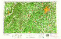
~ Atlanta GA topo map, 1:250000 scale, 1 X 2 Degree, Historical, 1953, updated 1965
Atlanta, Georgia, USGS topographic map dated 1953.
Includes geographic coordinates (latitude and longitude). This topographic map is suitable for hiking, camping, and exploring, or framing it as a wall map.
Printed on-demand using high resolution imagery, on heavy weight and acid free paper, or alternatively on a variety of synthetic materials.
Topos available on paper, Waterproof, Poly, or Tyvek. Usually shipping rolled, unless combined with other folded maps in one order.
- Product Number: USGS-5365338
- Free digital map download (high-resolution, GeoPDF): Atlanta, Georgia (file size: 24 MB)
- Map Size: please refer to the dimensions of the GeoPDF map above
- Weight (paper map): ca. 55 grams
- Map Type: POD USGS Topographic Map
- Map Series: HTMC
- Map Verison: Historical
- Cell ID: 68653
- Scan ID: 247821
- Imprint Year: 1965
- Woodland Tint: Yes
- Aerial Photo Year: 1947
- Edit Year: 1964
- Field Check Year: 1953
- Datum: Unstated
- Map Projection: Transverse Mercator
- Map published by United States Geological Survey
- Map Language: English
- Scanner Resolution: 600 dpi
- Map Cell Name: Atlanta
- Grid size: 1 X 2 Degree
- Date on map: 1953
- Map Scale: 1:250000
- Geographical region: Georgia, United States
Neighboring Maps:
All neighboring USGS topo maps are available for sale online at a variety of scales.
Spatial coverage:
Topo map Atlanta, Georgia, covers the geographical area associated the following places:
- Gordon Woods - Macland Springs - Gresham Park - Hartfield Estates - Shelby Forest - Smoke Rise Plantation - The Oaks - Lenox Park - Gardner Woods - Mountain View - Ridgeview Forest - Forest Brook - Braelinn Courts - Circle Creek - Rolling Meadows - Milltown - Four Mile - Old Ford Acres - Creek Indian - Tuxedo Estates - Hasford Estates - Weaver - Brownsville - Brock - Lake Island Estates - Ranburne - Liberty - South Gate - Creekwood Estates - Wewoka Estates - Oakhill - Kings Mountain - Rockridge - Executive Heights - Paces Lakes - Walthrall (historical) - Riverdale Acres - Payton (historical) - Aubrey - East Lake - Pleasant Valley - Capstan (historical) - Bud - North Druid Hills - Flat Shoals Estates - Allie - Tennant - Burnham Woods - Ponderosa Mobile Home Park - Enon Forest - Pinckneyville (historical) - Ingram Wells - Emuckfaw (historical) - Unity Grove - Weathers - Lithia Mobile Home Estates - Inman Park - Philadelphia - Clackville - Mechanicsville - Red Gate Estates - Cedron - Highland - Erin - Quail Run East - Jackson Township - Julia - Greenwich Woods Estates - Ashley Acres - Everhill - Oxford - Rainbow Estates - Plymouth Colony - Rovena Acres - Panola - Pinehurst - Mableton - Miller Academy - Green Meadows - Hearthwood - Five Notch Acres - Riverchase - Cambridge - Woodcrest - Pleasant Hill - Quail Valley - Aberdeen - Plainview - New Hope - Westward Ho - La Bama - Lakeview Meadows - Hilderbrand - Bethesda Woods South - Rosedale Heights - Greenacres - Norris Lake Shores - Treetop - Goodwin Crossing (historical) - Neal
- Map Area ID: AREA3433-86-84
- Northwest corner Lat/Long code: USGSNW34-86
- Northeast corner Lat/Long code: USGSNE34-84
- Southwest corner Lat/Long code: USGSSW33-86
- Southeast corner Lat/Long code: USGSSE33-84
- Northern map edge Latitude: 34
- Southern map edge Latitude: 33
- Western map edge Longitude: -86
- Eastern map edge Longitude: -84


