
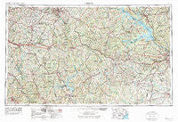
~ Athens GA topo map, 1:250000 scale, 1 X 2 Degree, Historical, 1953, updated 1974
Athens, Georgia, USGS topographic map dated 1953.
Includes geographic coordinates (latitude and longitude). This topographic map is suitable for hiking, camping, and exploring, or framing it as a wall map.
Printed on-demand using high resolution imagery, on heavy weight and acid free paper, or alternatively on a variety of synthetic materials.
Topos available on paper, Waterproof, Poly, or Tyvek. Usually shipping rolled, unless combined with other folded maps in one order.
- Product Number: USGS-5365334
- Free digital map download (high-resolution, GeoPDF): Athens, Georgia (file size: 22 MB)
- Map Size: please refer to the dimensions of the GeoPDF map above
- Weight (paper map): ca. 55 grams
- Map Type: POD USGS Topographic Map
- Map Series: HTMC
- Map Verison: Historical
- Cell ID: 68652
- Scan ID: 247819
- Imprint Year: 1974
- Woodland Tint: Yes
- Visual Version Number: 2
- Aerial Photo Year: 1948
- Edit Year: 1965
- Field Check Year: 1953
- Datum: Unstated
- Map Projection: Transverse Mercator
- Map published by United States Geological Survey
- Map published by United States Army Corps of Engineers
- Map published by United States Army
- Map Language: English
- Scanner Resolution: 600 dpi
- Map Cell Name: Athens
- Grid size: 1 X 2 Degree
- Date on map: 1953
- Map Scale: 1:250000
- Geographical region: Georgia, United States
Neighboring Maps:
All neighboring USGS topo maps are available for sale online at a variety of scales.
Spatial coverage:
Topo map Athens, Georgia, covers the geographical area associated the following places:
- Smiths Mill (historical) - Laurel Chase - Lexington Estates - Wrightsboro - Elder Heights - Smyrna - Broughton - Davis Estates - Swaggy Valley - Maysville (historical) - Flovilla - Stapleton - Callaway - Melody - Zingara - Hallwood - Jackson - McElroys Mill - Falcon Ridge - Madison - Rutherford (historical) - Green Meadows Estates - Glenford (historical) - Shady Dale - Lyneville - Westwick - Walnut Grove - Oakwood - Little River - Salem (historical) - Thigpen - Sandlewood - Long Acres - Briarwood - Ridgewood - Summit Grove - Forest River - Atwell - Double Branches - Newborn - Lake Royal - Anne Heights - Antioch - Carriage Court - Clay Hill - Wynngate - Springfield - Crawfordville - Halls Crossing - Bradley - Highview Acres - Hardwick - Gratis - Whispering Pine Mobile Home Park - Chimney Hill - Almon - Sybert - Magnolia - Red Fox - Belair - Beverly Heights - Pine Lake - Columbia Heights - Adamsville - Beulah - Poplar Springs - Hidden Pines - Dickson - Surry Chase - Salem Branch - Canaan - Liberty Hill - Oak Lake - Forest Mill - Rayle - Woodlawn - Blackwell - Epps Bridge Crossing - Campbell (historical) - Cedar Bluff - Union Point - Youth - Chalker (historical) - Foxhall - Iron Springs Crossroads - Chatfield (historical) - Avondale - Bayvale - Golden Terrace - Woodville - Shenandoah - Between - University Heights - Essex - Hatchers Store - Starrsville - Palato - Jacksonville - Barrow Heights - Edgehill
- Map Area ID: AREA3433-84-82
- Northwest corner Lat/Long code: USGSNW34-84
- Northeast corner Lat/Long code: USGSNE34-82
- Southwest corner Lat/Long code: USGSSW33-84
- Southeast corner Lat/Long code: USGSSE33-82
- Northern map edge Latitude: 34
- Southern map edge Latitude: 33
- Western map edge Longitude: -84
- Eastern map edge Longitude: -82


