
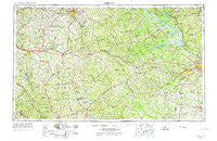
~ Athens GA topo map, 1:250000 scale, 1 X 2 Degree, Historical, 1953, updated 1974
Athens, Georgia, USGS topographic map dated 1953.
Includes geographic coordinates (latitude and longitude). This topographic map is suitable for hiking, camping, and exploring, or framing it as a wall map.
Printed on-demand using high resolution imagery, on heavy weight and acid free paper, or alternatively on a variety of synthetic materials.
Topos available on paper, Waterproof, Poly, or Tyvek. Usually shipping rolled, unless combined with other folded maps in one order.
- Product Number: USGS-5365330
- Free digital map download (high-resolution, GeoPDF): Athens, Georgia (file size: 21 MB)
- Map Size: please refer to the dimensions of the GeoPDF map above
- Weight (paper map): ca. 55 grams
- Map Type: POD USGS Topographic Map
- Map Series: HTMC
- Map Verison: Historical
- Cell ID: 68652
- Scan ID: 247817
- Imprint Year: 1974
- Woodland Tint: Yes
- Visual Version Number: 1
- Aerial Photo Year: 1956
- Edit Year: 1965
- Field Check Year: 1953
- Datum: Unstated
- Map Projection: Transverse Mercator
- Map published by United States Geological Survey
- Map published by United States Army Corps of Engineers
- Map published by United States Army
- Map Language: English
- Scanner Resolution: 600 dpi
- Map Cell Name: Athens
- Grid size: 1 X 2 Degree
- Date on map: 1953
- Map Scale: 1:250000
- Geographical region: Georgia, United States
Neighboring Maps:
All neighboring USGS topo maps are available for sale online at a variety of scales.
Spatial coverage:
Topo map Athens, Georgia, covers the geographical area associated the following places:
- Fairview - Tramlin Acres - Mitchell - Plantation Acres Mobile Home Park - Ashland - Shoulderbone - Lakeside Hills - Oak Ridge - Sandlewood - Green Acres - Glenwood - Twin Oaks - Kirkland Acres - Village Gate - Danson Woods - Laurel Hill - Campania - Zingara - Lincolnton - Westchester - Spartan Lane - Chadds Walk - Alcovy Forest - Casa Linda - Riverbend Farms - Homewood Hills - Creekwood Estates - Gratis - Cedar Creek - Hayston - Padgett Crossing (historical) - Echo Brook Park - Rushwood - Millers Crossroads - East Warrenton - Westwick - Fleming Heights - Double Branches - Goshen - Lamkin - Haddock - Fort Gordon - Oak Point - Bristol Wood - Greene - Woodland - Beechwood Hills - Allenwood - Ethridge - Jersey - Tallassee Estates - Beulah - Maple Creek - West Hills - Veazey - Stapleton - The Station - Smyrna - Mount Vernon - Barnett Bluffs - Adasburg - Chamberlin - Raes (historical) - Martinez - Ridgeway - Petersburg Station - Shady Dale - Berckman Villas - Little River - Briarwood - Warfield - Bostwick - Ridgewood - Shiloh Terrace - Riverbend East - Forest Heights - Montclair - Forest Park - Crawford - Mount Zion - Mayfair - Ridge Crossing - Cobbham (historical) - Black Spring - Norwood - Phoenix - Woodridge North - Bel Air Heights - Laurel Chase - Anne Heights - Southlands - Amity - Bradley - Harbin - Atwell - Country Wood - Edgewood Crossroads - Hidden Pines - Forrest (historical) - Burch Grant
- Map Area ID: AREA3433-84-82
- Northwest corner Lat/Long code: USGSNW34-84
- Northeast corner Lat/Long code: USGSNE34-82
- Southwest corner Lat/Long code: USGSSW33-84
- Southeast corner Lat/Long code: USGSSE33-82
- Northern map edge Latitude: 34
- Southern map edge Latitude: 33
- Western map edge Longitude: -84
- Eastern map edge Longitude: -82


