
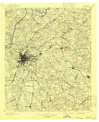
~ Atlanta GA topo map, 1:125000 scale, 30 X 30 Minute, Historical, 1895, updated 1941
Atlanta, Georgia, USGS topographic map dated 1895.
Includes geographic coordinates (latitude and longitude). This topographic map is suitable for hiking, camping, and exploring, or framing it as a wall map.
Printed on-demand using high resolution imagery, on heavy weight and acid free paper, or alternatively on a variety of synthetic materials.
Topos available on paper, Waterproof, Poly, or Tyvek. Usually shipping rolled, unless combined with other folded maps in one order.
- Product Number: USGS-5365152
- Free digital map download (high-resolution, GeoPDF): Atlanta, Georgia (file size: 9 MB)
- Map Size: please refer to the dimensions of the GeoPDF map above
- Weight (paper map): ca. 55 grams
- Map Type: POD USGS Topographic Map
- Map Series: HTMC
- Map Verison: Historical
- Cell ID: 64926
- Scan ID: 247682
- Imprint Year: 1941
- Survey Year: 1888
- Datum: Unstated
- Map Projection: Polyconic
- Map published by United States Geological Survey
- Map Language: English
- Scanner Resolution: 600 dpi
- Map Cell Name: Atlanta
- Grid size: 30 X 30 Minute
- Date on map: 1895
- Map Scale: 1:125000
- Geographical region: Georgia, United States
Neighboring Maps:
All neighboring USGS topo maps are available for sale online at a variety of scales.
Spatial coverage:
Topo map Atlanta, Georgia, covers the geographical area associated the following places:
- Cricket Hill - Smoke Ridge - Burkshire - Evans Park - Pittman - Harbin Acres - Kenwood Forest - West End Park - The Highlands - Hidden Acres of Fayette - Stoneview Acres - Kirkwood - Gloster - Forest Hills Mobile Home Park - Ashland Estates - Pinecrest Forest - Glen Leaf - Sussex Manor - Friendship - Meadow - Brownwood Acres - Bretton Woods - Linwood - Ingleside - Patillo Point - Corinth Hills - Saranac - Sweetbriar - Arbor West - Wewoka Estates - Peachtree Corners - Cherry Ridge - Bridgewater - Rovena Acres - Covered Bridge - English Avenue Neighborhood - River Oak - Lithonia - Howell Estates - Hidden Lakes - Trickem - Meadowview Acres - Valley Forest - Overlook - Coxs Crossing - Peachtree Forest - Fontainbleau Forest - Chelsea Park - Timberlake - Regal Estates - Stockbridge - Frog Hollow - The Highlands at Akers - Sun Valley - Verdon Forest - Tolliver Heights - Woodland Hills - Cornell - Misty Ridge - Stone Mill Run - Julia - The Meadows - Old South - Ridgewood - Oakland North - Hapeville - Elmwood - Five Points - Autumn Chase - Sylvan Hills - Palisades Estates - Southbridge - Windwood - Luxomni - Littlebrooke Farm - Beaver Creek - Berkshire (historical) - Cabbage Town - Beaver Hills - Clearbrook - Emory - Helmer - Bobilin Estates - Inglenook - Newton Plantation - Ansley Pointe - Fairview Station - Emerald Hills - Springfield - Cedar Creek - Lafayette Estates - Comfort Hill - Stoneridge - Mountain Park - Northridge - Rolling Meadows - Chimney Ridge - Velta - River Bridge - Goodwin Crossing (historical)
- Map Area ID: AREA3433.5-84.5-84
- Northwest corner Lat/Long code: USGSNW34-84.5
- Northeast corner Lat/Long code: USGSNE34-84
- Southwest corner Lat/Long code: USGSSW33.5-84.5
- Southeast corner Lat/Long code: USGSSE33.5-84
- Northern map edge Latitude: 34
- Southern map edge Latitude: 33.5
- Western map edge Longitude: -84.5
- Eastern map edge Longitude: -84


