
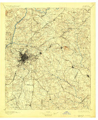
~ Atlanta GA topo map, 1:125000 scale, 30 X 30 Minute, Historical, 1895, updated 1926
Atlanta, Georgia, USGS topographic map dated 1895.
Includes geographic coordinates (latitude and longitude). This topographic map is suitable for hiking, camping, and exploring, or framing it as a wall map.
Printed on-demand using high resolution imagery, on heavy weight and acid free paper, or alternatively on a variety of synthetic materials.
Topos available on paper, Waterproof, Poly, or Tyvek. Usually shipping rolled, unless combined with other folded maps in one order.
- Product Number: USGS-5365148
- Free digital map download (high-resolution, GeoPDF): Atlanta, Georgia (file size: 9 MB)
- Map Size: please refer to the dimensions of the GeoPDF map above
- Weight (paper map): ca. 55 grams
- Map Type: POD USGS Topographic Map
- Map Series: HTMC
- Map Verison: Historical
- Cell ID: 64926
- Scan ID: 247678
- Imprint Year: 1926
- Survey Year: 1888
- Datum: NAD
- Map Projection: Polyconic
- Map published by United States Geological Survey
- Map Language: English
- Scanner Resolution: 600 dpi
- Map Cell Name: Atlanta
- Grid size: 30 X 30 Minute
- Date on map: 1895
- Map Scale: 1:125000
- Geographical region: Georgia, United States
Neighboring Maps:
All neighboring USGS topo maps are available for sale online at a variety of scales.
Spatial coverage:
Topo map Atlanta, Georgia, covers the geographical area associated the following places:
- Four Winds - Whitehall Forest Estates - Mount Vernon Lake - Hapeville - Chapel Hill - Oak Village - Beulah Heights - Oakwood Manor - Coldstream - Lenox Park - Trickem - Vinings - Klondike - Red Oak - Hopeful - The Corners - Brandington Forest - Peachtree Forest - Castile Cove - Country Roads - Hyde Park - Rose Garden Hills - Camelot Club - Beaverdam (historical) - West End - Hidden Acres of Fayette - Windermere Woods - Country Square - Salem West - Dove Rest - Carnegie Place - Stone Creek - Druid Hills - Chelsea Heights - Blakeford - Pleasant Acres - Cotton Creek - Monterey Acres - Montreal - Meadow - Chapel Mill - North Clayton - Laurel Woods - Countryside Village Mobile Home Park - Williams Place - Bethesda - Malibu - The Meadows - Fleming (historical) - The Inlet - Peachtree Station - Park South - Cameron Glen - Vine City - Northside Park - Grove Park - Rex - Chelsea Park - Ace Mobile Home Park - Murphyville - Mountain View Plaza - Sherwood Park - Duval - Spivey Chase - North DeKalb - Chattahoochee - Mill Glen - Cabbage Town - Oakland North - Tilford - Belvedere Park - Pinebrook Heights - Windy Hill Manor - Humphries (historical) - Aspen Acres - Fairington - Bentbrook Farms - Waterford - Windsor Heights - Windhaven - Pine Lake - Hidden Valley - Jonesboro - Fernwood - Gloster - Green Meadows - River Bridge - Copen Hill - Inman Park - Edgewood - River Oak - Jones Mobile Home Park - Mechanicsville - Ingleside - Oak View Homes - Biscayne Club - Atlanta - Steeplechase - Bramblewood - Pinecrest Hills
- Map Area ID: AREA3433.5-84.5-84
- Northwest corner Lat/Long code: USGSNW34-84.5
- Northeast corner Lat/Long code: USGSNE34-84
- Southwest corner Lat/Long code: USGSSW33.5-84.5
- Southeast corner Lat/Long code: USGSSE33.5-84
- Northern map edge Latitude: 34
- Southern map edge Latitude: 33.5
- Western map edge Longitude: -84.5
- Eastern map edge Longitude: -84


