
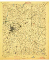
~ Atlanta GA topo map, 1:125000 scale, 30 X 30 Minute, Historical, 1895, updated 1900
Atlanta, Georgia, USGS topographic map dated 1895.
Includes geographic coordinates (latitude and longitude). This topographic map is suitable for hiking, camping, and exploring, or framing it as a wall map.
Printed on-demand using high resolution imagery, on heavy weight and acid free paper, or alternatively on a variety of synthetic materials.
Topos available on paper, Waterproof, Poly, or Tyvek. Usually shipping rolled, unless combined with other folded maps in one order.
- Product Number: USGS-5365142
- Free digital map download (high-resolution, GeoPDF): Atlanta, Georgia (file size: 9 MB)
- Map Size: please refer to the dimensions of the GeoPDF map above
- Weight (paper map): ca. 55 grams
- Map Type: POD USGS Topographic Map
- Map Series: HTMC
- Map Verison: Historical
- Cell ID: 64926
- Scan ID: 247675
- Imprint Year: 1900
- Survey Year: 1888
- Datum: Unstated
- Map Projection: Unstated
- Map published by United States Geological Survey
- Map Language: English
- Scanner Resolution: 600 dpi
- Map Cell Name: Atlanta
- Grid size: 30 X 30 Minute
- Date on map: 1895
- Map Scale: 1:125000
- Geographical region: Georgia, United States
Neighboring Maps:
All neighboring USGS topo maps are available for sale online at a variety of scales.
Spatial coverage:
Topo map Atlanta, Georgia, covers the geographical area associated the following places:
- Kings Row - Pittman - Evans Park - DeKalb Highlands - Willow Creek Estates - Edgemoor - Bentbrook Farms - Chippewa Forest - Klondike - Friendship - Lochwolde - Conyers - River Hills - Dunwoody Knoll - Avalon - Carnegie Place - Cricket Hill - Cameron Glen - River Bridge - Glen Haven - Carey Park - Smoketree - Brownwood Acres - Otranto Hills - Brandy Chase - Saranac Estates - Roundtree Estates - Cedar Hill Estates - Park Villas - Collinsville - Barcelona Estates - Rio Ranch - Miralia - Vine City - Clarkston - Parkwood - Park South - Park Place South - Ashebrook - Ellen - Lester Woods - North River Crossing - Haasville (historical) - Stonewall - Mason Woods - Charlotte Woods - River Valley Estates - Huntley Hill - North Atlanta - Hopkins Mill - Luxomni - Castlegate - Redfield - Williams Place - Buchanan (historical) - Thornton Woods - Twin Village - Old Ford Acres - Joel Chandler Harris Homes - Sweet Water - Belmont - Kimberly - Riversong - Gloster - Brownwood - Monterey Acres - Stone Creek - Whitehall Forest Estates - Sterling Acres - Ridgecrest - Benton Harbor - Mockingbird Hill - Post River - Meadowview Acres - Valley Woods - Mountain Brooke - Sherwood Forest - Gamma - Riverwood - Emerald Forest - Jones Mobile Home Park - Lake Colony - Oak Point - Knollwood - Cambridge Estates - Elizabeth Park - Oakbrook Station - Arrowind - Briar Glen - North Fayette Estates - Miners Creek - Thomasville - Peachtree Forest - Chase Woods - Lake Tara - Wildwood Estates - Glenwoods - Southbridge - Covered Bridge - Gresham Park
- Map Area ID: AREA3433.5-84.5-84
- Northwest corner Lat/Long code: USGSNW34-84.5
- Northeast corner Lat/Long code: USGSNE34-84
- Southwest corner Lat/Long code: USGSSW33.5-84.5
- Southeast corner Lat/Long code: USGSSE33.5-84
- Northern map edge Latitude: 34
- Southern map edge Latitude: 33.5
- Western map edge Longitude: -84.5
- Eastern map edge Longitude: -84


