
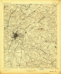
~ Atlanta GA topo map, 1:125000 scale, 30 X 30 Minute, Historical, 1895
Atlanta, Georgia, USGS topographic map dated 1895.
Includes geographic coordinates (latitude and longitude). This topographic map is suitable for hiking, camping, and exploring, or framing it as a wall map.
Printed on-demand using high resolution imagery, on heavy weight and acid free paper, or alternatively on a variety of synthetic materials.
Topos available on paper, Waterproof, Poly, or Tyvek. Usually shipping rolled, unless combined with other folded maps in one order.
- Product Number: USGS-5365140
- Free digital map download (high-resolution, GeoPDF): Atlanta, Georgia (file size: 9 MB)
- Map Size: please refer to the dimensions of the GeoPDF map above
- Weight (paper map): ca. 55 grams
- Map Type: POD USGS Topographic Map
- Map Series: HTMC
- Map Verison: Historical
- Cell ID: 64926
- Scan ID: 247672
- Survey Year: 1888
- Datum: Unstated
- Map Projection: Unstated
- Map published by United States Geological Survey
- Map Language: English
- Scanner Resolution: 600 dpi
- Map Cell Name: Atlanta
- Grid size: 30 X 30 Minute
- Date on map: 1895
- Map Scale: 1:125000
- Geographical region: Georgia, United States
Neighboring Maps:
All neighboring USGS topo maps are available for sale online at a variety of scales.
Spatial coverage:
Topo map Atlanta, Georgia, covers the geographical area associated the following places:
- Dunwoody Heights - Woodmere - Valley Woods - Summerville - Franklin Farms - Oakhurst - West End - Hollydale - Embrey Hills - College Park - The Moorings - Yellow River (historical) - Otranto Hills - Morningside - Lenora - Berkeley Manor - Mountain Park - Lexington Creek - Fay (historical) - Brookfield Woods - Lake Colony - Springview - Hanarry Estates - Autumn Chase - Bristol Downs - Camp Creek Estates - Mountain Woods - Murphyville - Sioux Acres Mobile Home Park - Deerfield - Benton Harbor - Meadow Hills - Katherine Valley - Hopeful - Palisades Estates - Sun Valley - Belmont - North Clayton - Salem West - Brook Glen - Monterey - Pinebrook Heights - Wallace (historical) - Pine Grove Trailer Park - Evans Park - Brandy Chase - East Lake - Skyline Forest - Lafayette Estates - Caleb - Jones Bridge Landing - Post Harbor - Pittman - Timber Trace - Oak Ridge - Wilshire - Flintlook - Steeplechase - Conley - Woodland Hills Mobile Home Park - Hickory Hills - Brannan - Riverside Station - Decatur - Beaver Lake Estates - Haven Park - Ridgeview Forest - Rock Chapel - Oakengate - Indian Hill Estates - Knob (historical) - Hunters Glen - Paradise Park - Jarrard - Manor Ridge Park - Windhaven Plantation - Park Villas - Crossgate - Idlewood Acres - Turner Village - Clayton Ridge North - Capitol View - Constitution - Klondike - Tara Heights - Red Oak - Meadow - Camelot Club - Old National East - Williams Place - Jones Mobile Home Park - Sylvan Hills - Cricket Hill - Treetop - Cheney (historical) - Berkeley Hills - Briargate - Sherwood Forest - Wilkshire Estates - Pine Mountain
- Map Area ID: AREA3433.5-84.5-84
- Northwest corner Lat/Long code: USGSNW34-84.5
- Northeast corner Lat/Long code: USGSNE34-84
- Southwest corner Lat/Long code: USGSSW33.5-84.5
- Southeast corner Lat/Long code: USGSSE33.5-84
- Northern map edge Latitude: 34
- Southern map edge Latitude: 33.5
- Western map edge Longitude: -84.5
- Eastern map edge Longitude: -84


