
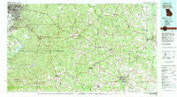
~ Americus GA topo map, 1:100000 scale, 30 X 60 Minute, Historical, 1981, updated 1982
Americus, Georgia, USGS topographic map dated 1981.
Includes geographic coordinates (latitude and longitude). This topographic map is suitable for hiking, camping, and exploring, or framing it as a wall map.
Printed on-demand using high resolution imagery, on heavy weight and acid free paper, or alternatively on a variety of synthetic materials.
Topos available on paper, Waterproof, Poly, or Tyvek. Usually shipping rolled, unless combined with other folded maps in one order.
- Product Number: USGS-5365068
- Free digital map download (high-resolution, GeoPDF): Americus, Georgia (file size: 32 MB)
- Map Size: please refer to the dimensions of the GeoPDF map above
- Weight (paper map): ca. 55 grams
- Map Type: POD USGS Topographic Map
- Map Series: HTMC
- Map Verison: Historical
- Cell ID: 67041
- Scan ID: 247617
- Imprint Year: 1982
- Woodland Tint: Yes
- Aerial Photo Year: 1973
- Edit Year: 1981
- Datum: NAD27
- Map Projection: Universal Transverse Mercator
- Map published by United States Geological Survey
- Map Language: English
- Scanner Resolution: 600 dpi
- Map Cell Name: Americus
- Grid size: 30 X 60 Minute
- Date on map: 1981
- Map Scale: 1:100000
- Geographical region: Georgia, United States
Neighboring Maps:
All neighboring USGS topo maps are available for sale online at a variety of scales.
Spatial coverage:
Topo map Americus, Georgia, covers the geographical area associated the following places:
- Gooseberry (historical) - Buena Vista Heights - Huntington - Richland - Meadow Wood Park - Archery - Englewood - Custer Road Terrace - Dumas - Myrtle Springs (historical) - Garrett Heights - Doyle - Sheraton Forest - Hoggs (historical) - Ochillee - Friendship - Church Hill - Glen Alta - Quail Creek - Hicks - Perkins Place - Cusseta - Pinewood - Travelers Rest - City Village - Slaughter Creek (historical) - Battle Forest - Shack (historical) - Rose Hill - Americus - Five Points - Bibb City - Concord - Battle Park - Brookridge - Holly Hills - Garden Valley - Bumphead - La Crosse - Cherokee Park - Wickham Heights - Northside Homes - Magnolia Grove - Concord - Columbia Heights - Charles - Hilton Heights - Taylors Woods - Brooklyn - Branton Woods - Levy - City View Heights - Forest Hills - Fort Benning - Forest Heights - Oglethorpe - Renfroe - Crossgate - Kasihta (historical) - Cottage Mills (historical) - Broadmoor - Putnam - Wynnton Grove - Hillside Terrace - Blueville - Esquiline (historical) - Pineville - Louvale - Farrwood Park - Andersonville - Wynnton - Upper Bradley Place - Shady Grove - Wellington - Clubview Heights - Roosevelt Heights - Avondale - Magnolia Springs (historical) - Forestdale - Riverland Terrace - Belvedere Park - Edgewood Forest - Briarwood - Baker Village - Wesley Heights - Plains - Apalatchukla (historical) - Ridgeview Heights - Booker Washington Heights - Tara - Linden - Forest Park - Walls Crossing - Christopher - Columbus - Starmount - Holly Woods - Beatrice - Northstar - Green Hill (historical)
- Map Area ID: AREA32.532-85-84
- Northwest corner Lat/Long code: USGSNW32.5-85
- Northeast corner Lat/Long code: USGSNE32.5-84
- Southwest corner Lat/Long code: USGSSW32-85
- Southeast corner Lat/Long code: USGSSE32-84
- Northern map edge Latitude: 32.5
- Southern map edge Latitude: 32
- Western map edge Longitude: -85
- Eastern map edge Longitude: -84


