
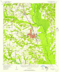
~ Warner Robins GA topo map, 1:62500 scale, 15 X 15 Minute, Historical, 1956, updated 1957
Warner Robins, Georgia, USGS topographic map dated 1956.
Includes geographic coordinates (latitude and longitude). This topographic map is suitable for hiking, camping, and exploring, or framing it as a wall map.
Printed on-demand using high resolution imagery, on heavy weight and acid free paper, or alternatively on a variety of synthetic materials.
Topos available on paper, Waterproof, Poly, or Tyvek. Usually shipping rolled, unless combined with other folded maps in one order.
- Product Number: USGS-5365054
- Free digital map download (high-resolution, GeoPDF): Warner Robins, Georgia (file size: 7 MB)
- Map Size: please refer to the dimensions of the GeoPDF map above
- Weight (paper map): ca. 55 grams
- Map Type: POD USGS Topographic Map
- Map Series: HTMC
- Map Verison: Historical
- Cell ID: 64237
- Scan ID: 247607
- Imprint Year: 1957
- Woodland Tint: Yes
- Aerial Photo Year: 1955
- Field Check Year: 1956
- Datum: NAD27
- Map Projection: Polyconic
- Map published by United States Geological Survey
- Map Language: English
- Scanner Resolution: 600 dpi
- Map Cell Name: Warner Robins
- Grid size: 15 X 15 Minute
- Date on map: 1956
- Map Scale: 1:62500
- Geographical region: Georgia, United States
Neighboring Maps:
All neighboring USGS topo maps are available for sale online at a variety of scales.
Spatial coverage:
Topo map Warner Robins, Georgia, covers the geographical area associated the following places:
- Fox Meadow Estates - Cardinal Ridge - Rutland - Highland Estates - Tharpe (historical) - Mason Subdivision - Holly Bluff - Wrights Mill - Elberta - Heard - Lakeview - Fairview Estates - Claybed - Kewanee Farms - Sonja Heights - Shady Grove - Honey Ridge Plantation - Quail Run North - Doublegate - Stathams Landing - Bass - Hickory Woods - O'Reily Estates - Molena Mobile Home Park - Woodfield Subdivision - Placid Acres Mobile Home Park - Lake Sardis Estates - Quail Run - Jones Road Subdivision - Woodard Estates - Elmdale Estates - Sardis Estates - Dove Cove - Huber - Crestwood Estates - Russell Glen - Creekside - South Springs - Bonaire Heights - Liberty View - Sedgefield - Houston Lake Woods - Barrington - River West - Skipperton - Sofkee - Idlewood Acres - Redding - Fairystone - Bevinwood - Betty Mobile Home Park - Turtle Creek - Hunters Ridge - Echeconnee - Pilgrim Rest - Beaver Creek - Danes Meadow - Bonaire - The Heather on Houston Lake - Sleepy Hollow - Aultman Pines - South Oaks - Windsor Forest - Wallston - Forest Pointe - Kings Crossing - Peachtree Estates - Hidden Oaks - Robins Forest West - Richardson Estates - Antebellum Plateau - Three Oaks - Centerville - Reids - Devereaux Estates - Lashley - Waterford South - Avondale - Settlers Landing - South Pointe - Warner Robins - Vonreg Subdivision - Deerwood - Woody Acres - Goodall Estates - Pike Acres - Ashlund Ridge - Antebellum North - Quail Meadow - Quail Run North - Pine Forest - Shirley Hills Estates - Walden - Wellington Woods - Echo Glen
- Map Area ID: AREA32.7532.5-83.75-83.5
- Northwest corner Lat/Long code: USGSNW32.75-83.75
- Northeast corner Lat/Long code: USGSNE32.75-83.5
- Southwest corner Lat/Long code: USGSSW32.5-83.75
- Southeast corner Lat/Long code: USGSSE32.5-83.5
- Northern map edge Latitude: 32.75
- Southern map edge Latitude: 32.5
- Western map edge Longitude: -83.75
- Eastern map edge Longitude: -83.5


