
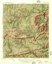
~ Warm Springs GA topo map, 1:62500 scale, 15 X 15 Minute, Historical, 1936, updated 1945
Warm Springs, Georgia, USGS topographic map dated 1936.
Includes geographic coordinates (latitude and longitude). This topographic map is suitable for hiking, camping, and exploring, or framing it as a wall map.
Printed on-demand using high resolution imagery, on heavy weight and acid free paper, or alternatively on a variety of synthetic materials.
Topos available on paper, Waterproof, Poly, or Tyvek. Usually shipping rolled, unless combined with other folded maps in one order.
- Product Number: USGS-5365052
- Free digital map download (high-resolution, GeoPDF): Warm Springs, Georgia (file size: 14 MB)
- Map Size: please refer to the dimensions of the GeoPDF map above
- Weight (paper map): ca. 55 grams
- Map Type: POD USGS Topographic Map
- Map Series: HTMC
- Map Verison: Historical
- Cell ID: 64232
- Scan ID: 247603
- Imprint Year: 1945
- Survey Year: 1934
- Datum: NAD27
- Map Projection: Polyconic
- Shaded Relief map: Yes
- Map published by United States Geological Survey
- Map Language: English
- Scanner Resolution: 600 dpi
- Map Cell Name: Warm Springs
- Grid size: 15 X 15 Minute
- Date on map: 1936
- Map Scale: 1:62500
- Geographical region: Georgia, United States
Neighboring Maps:
All neighboring USGS topo maps are available for sale online at a variety of scales.
Spatial coverage:
Topo map Warm Springs, Georgia, covers the geographical area associated the following places:
- Persico - Flint Hill - Shiloh - Woodland - Tax Crossroads - Nebula - Bulloch Crossroads - Johnson Crossroads - Bussey Crossroads - Bullochville (historical) - Langdon - Cunningham Crossroads - Betts - Sardis - Oak Mountain Spring (historical) - Harris City - Loftin - McLendon Crossroads - Warm Springs - Andrews Crossroads - Greens Mill - Barnes Crossroads - Belleview - Chalybeate Springs - Routons Crossroads - Raleigh - Snelsons Crossroads - Woodbury - Manchester - Crowders Crossing - Hawkins Crossroads
- Map Area ID: AREA3332.75-84.75-84.5
- Northwest corner Lat/Long code: USGSNW33-84.75
- Northeast corner Lat/Long code: USGSNE33-84.5
- Southwest corner Lat/Long code: USGSSW32.75-84.75
- Southeast corner Lat/Long code: USGSSE32.75-84.5
- Northern map edge Latitude: 33
- Southern map edge Latitude: 32.75
- Western map edge Longitude: -84.75
- Eastern map edge Longitude: -84.5


