
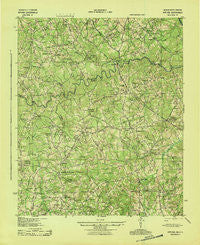
~ Appling GA topo map, 1:62500 scale, 15 X 15 Minute, Historical, 1943
Appling, Georgia, USGS topographic map dated 1943.
Includes geographic coordinates (latitude and longitude). This topographic map is suitable for hiking, camping, and exploring, or framing it as a wall map.
Printed on-demand using high resolution imagery, on heavy weight and acid free paper, or alternatively on a variety of synthetic materials.
Topos available on paper, Waterproof, Poly, or Tyvek. Usually shipping rolled, unless combined with other folded maps in one order.
- Product Number: USGS-5364658
- Free digital map download (high-resolution, GeoPDF): Appling, Georgia (file size: 10 MB)
- Map Size: please refer to the dimensions of the GeoPDF map above
- Weight (paper map): ca. 55 grams
- Map Type: POD USGS Topographic Map
- Map Series: HTMC
- Map Verison: Historical
- Cell ID: 50632
- Scan ID: 247339
- Woodland Tint: Yes
- Aerial Photo Year: 1941
- Survey Year: 1919
- Datum: NAD27
- Map Projection: Polyconic
- Map published by United States Army Corps of Engineers
- Map published by United States Army
- Map published by United States Department of War
- Map Language: English
- Scanner Resolution: 600 dpi
- Map Cell Name: Appling
- Grid size: 15 X 15 Minute
- Date on map: 1943
- Map Scale: 1:62500
- Geographical region: Georgia, United States
Neighboring Maps:
All neighboring USGS topo maps are available for sale online at a variety of scales.
Spatial coverage:
Topo map Appling, Georgia, covers the geographical area associated the following places:
- Dunn Chapel - Clay Hill - Salem (historical) - Eubank (historical) - Phinizy - Winfield - Loce - Bussey - Winfield Hill - Amity - Pollards Corner - Cobbham - Leathersville - New Hope - Stones Crossroads - Hamilton Crossroads - Rousseau Spring (historical) - Raysville - Leah - Agnes (historical) - Scuffletown - Delph (historical) - Shiloh (historical) - Woodlawn - Maddox - Cluese (historical) - Ansley Mill - Appling - Cobbham Crossroads - Howell
- Map Area ID: AREA33.7533.5-82.5-82.25
- Northwest corner Lat/Long code: USGSNW33.75-82.5
- Northeast corner Lat/Long code: USGSNE33.75-82.25
- Southwest corner Lat/Long code: USGSSW33.5-82.5
- Southeast corner Lat/Long code: USGSSE33.5-82.25
- Northern map edge Latitude: 33.75
- Southern map edge Latitude: 33.5
- Western map edge Longitude: -82.5
- Eastern map edge Longitude: -82.25


