
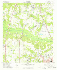
~ Warner Robins NW GA topo map, 1:24000 scale, 7.5 X 7.5 Minute, Historical, 1973, updated 1977
Warner Robins NW, Georgia, USGS topographic map dated 1973.
Includes geographic coordinates (latitude and longitude). This topographic map is suitable for hiking, camping, and exploring, or framing it as a wall map.
Printed on-demand using high resolution imagery, on heavy weight and acid free paper, or alternatively on a variety of synthetic materials.
Topos available on paper, Waterproof, Poly, or Tyvek. Usually shipping rolled, unless combined with other folded maps in one order.
- Product Number: USGS-5364496
- Free digital map download (high-resolution, GeoPDF): Warner Robins NW, Georgia (file size: 10 MB)
- Map Size: please refer to the dimensions of the GeoPDF map above
- Weight (paper map): ca. 55 grams
- Map Type: POD USGS Topographic Map
- Map Series: HTMC
- Map Verison: Historical
- Cell ID: 47499
- Scan ID: 247227
- Imprint Year: 1977
- Woodland Tint: Yes
- Aerial Photo Year: 1973
- Field Check Year: 1973
- Datum: NAD27
- Map Projection: Transverse Mercator
- Map published by United States Geological Survey
- Map Language: English
- Scanner Resolution: 600 dpi
- Map Cell Name: Warner Robins NW
- Grid size: 7.5 X 7.5 Minute
- Date on map: 1973
- Map Scale: 1:24000
- Geographical region: Georgia, United States
Neighboring Maps:
All neighboring USGS topo maps are available for sale online at a variety of scales.
Spatial coverage:
Topo map Warner Robins NW, Georgia, covers the geographical area associated the following places:
- Mason Subdivision - Vonreg Subdivision - Goodall Estates - O'Reily Estates - Betty Mobile Home Park - Rutland - Aultman Pines - Fairview Estates - Lake Sardis Estates - Crestwood Estates - Echo Glen - Three Oaks - Honey Ridge Plantation - Placid Acres Mobile Home Park - Danes Meadow - Wellington Woods - Bevinwood - Antebellum North - Kewanee Farms - Echeconnee - Antebellum Plateau - Ashlund Ridge - Skipperton - Sardis Estates - Jones Road Subdivision - Sedgefield - Pike Acres - Avondale - Molena Mobile Home Park - Hunters Ridge - Centerville - Fairystone - Liberty View - Walden - Fox Meadow Estates - Sofkee
- Map Area ID: AREA32.7532.625-83.75-83.625
- Northwest corner Lat/Long code: USGSNW32.75-83.75
- Northeast corner Lat/Long code: USGSNE32.75-83.625
- Southwest corner Lat/Long code: USGSSW32.625-83.75
- Southeast corner Lat/Long code: USGSSE32.625-83.625
- Northern map edge Latitude: 32.75
- Southern map edge Latitude: 32.625
- Western map edge Longitude: -83.75
- Eastern map edge Longitude: -83.625


