
~ Acworth GA topo map, 1:24000 scale, 7.5 X 7.5 Minute, Historical, 1992, updated 1993
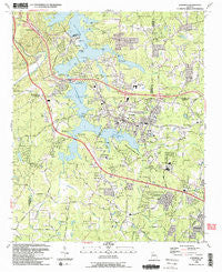
Acworth, Georgia, USGS topographic map dated 1992.
Includes geographic coordinates (latitude and longitude). This topographic map is suitable for hiking, camping, and exploring, or framing it as a wall map.
Printed on-demand using high resolution imagery, on heavy weight and acid free paper, or alternatively on a variety of synthetic materials.
Topos available on paper, Waterproof, Poly, or Tyvek. Usually shipping rolled, unless combined with other folded maps in one order.
- Product Number: USGS-5360302
- Free digital map download (high-resolution, GeoPDF): Acworth, Georgia (file size: 14 MB)
- Map Size: please refer to the dimensions of the GeoPDF map above
- Weight (paper map): ca. 55 grams
- Map Type: POD USGS Topographic Map
- Map Series: HTMC
- Map Verison: Historical
- Cell ID: 122
- Scan ID: 244861
- Imprint Year: 1993
- Woodland Tint: Yes
- Aerial Photo Year: 1988
- Edit Year: 1993
- Field Check Year: 1991
- Datum: NAD27
- Map Projection: Transverse Mercator
- Map published by United States Geological Survey
- Map Language: English
- Scanner Resolution: 600 dpi
- Map Cell Name: Acworth
- Grid size: 7.5 X 7.5 Minute
- Date on map: 1992
- Map Scale: 1:24000
- Geographical region: Georgia, United States
Neighboring Maps:
All neighboring USGS topo maps are available for sale online at a variety of scales.
Spatial coverage:
Topo map Acworth, Georgia, covers the geographical area associated the following places:
- Northwind - Pinehurst - Emerald Forest - Baker Ridge - Summer Trace - Acworth Beach - Cedar Crest Plantation - Picketts Plantation - Vestavia Estates - Twin Pines - Blue Springs Village Mobile Home Park - Allatoona Ridge - Payne Mobile Home Park - Edgewood Estates - Hills-A-Rolling - Plantation Walk - Green Hills Estates - Logan Trace - Sequoyah Estates - Etowah Mills - Shiloh West - Westwood Station - Lakeview Heights - Lake Manor - Mars Hill Acres - Emerald Willows - McCollum Acres - Modern Living Mobile Home Park - Calumet Woods - Valley Hill Estates - Nowlin Woods - Acworth Meadows - Allatoona - Logan Meadow - Acworth - Homestead Acres - Payne - Harris Woods - Allatoona Quarters - North Bend - Owens Meadows - Etowah Cove - Indian Village - Allatoona Shores - Allatoona Beach - Salem Woods - Lakewood Heights - Kennesaw Acres - Blue Springs - Greyfield North - Pages Mobile Home Park - Davenport Trace - Brookwood - Whites Lake - Hill Forest Estates - Mitchell Hill - Mars Hill - Allatoona Bay - Jarratt Crossing - Mars Hill Downs - Hunt Club - Big Shanty Hills - Picketts Mill - McGuire Heights - Allatoona Heights - Hunters Cove - Falcon Shores - Country Creek - Stilesboro Hills - Etheridge Glen - Picketts Crossing - Old Cedar Creek - Iron Hill - Countryside Estates - Signal Point - Yacht Club Estates - Bartow - Whitney Station - Cedar Mill Crossing - Laurel Hills - North Shores
- Map Area ID: AREA34.12534-84.75-84.625
- Northwest corner Lat/Long code: USGSNW34.125-84.75
- Northeast corner Lat/Long code: USGSNE34.125-84.625
- Southwest corner Lat/Long code: USGSSW34-84.75
- Southeast corner Lat/Long code: USGSSE34-84.625
- Northern map edge Latitude: 34.125
- Southern map edge Latitude: 34
- Western map edge Longitude: -84.75
- Eastern map edge Longitude: -84.625


