
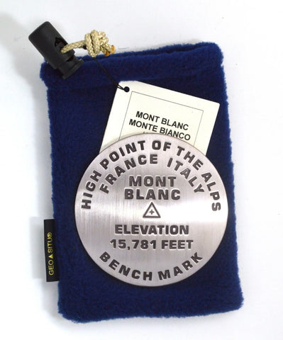
Mont Blanc, Alps high point benchmark paperweight
3 1/4 inch diameter
Cast in fine pewter
Felt backing
With soft fleece pouch
In clear-vinyl covered box
PLACE NAME: Mont Blanc
ELEVATION: 15781 ft.
COORDINATES: N45° 50 01 W06° 51 54
LOCATION: Graian Range of the Savoy Alps, France and Italy
The White Lady—La Dame Blanche—of France and Italy is a very popular destination for tourists and mountain sports enthusiasts—hikers, cyclists, skiers, snow-boarders, and mountaineers. She receives more than 20,000 climbers to the summit annually. The Tramway du Mont Blanc climbs to an elevation of 7,782 feet. The normal French climbing route starts there, at Nid dAigle and proceeds to the Tête Rousse Hut.
The summit elevation is imprecise. because the summit of Mont Blanc is covered with ice pack, which changes from year to year.
- Product Number: GSU_PW_MONT_BLANC
- Reference Product Number: 2306157M
- ISBN: - None -
- Map format: - None -
- Map type: Accessories - Other Accessories
- Geographical region: France,Switzerland


