


Destination Map, Blue Ridge Parkway by National Geographic Maps
• Waterproof • Tear-Resistant • Travel Map
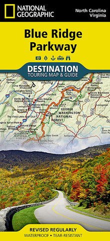
The Blue Ridge Parkway is a winding route that traverses some of Americas most picturesque scenery. The Parkway is Americas most visited National Park unit and when combined with Skyline Drive through Shenandoah National Park, also covered in detail on this map, a travel experience of over almost 600 miles is created. The Blue Ridge Parkway starts in the south at the foot of the Great Smoky Mountains and runs along the Blue Ridge through several National Forests from North Carolina and into Virginia.
National Geographics Blue Ridge Parkway Destination Map strikes the perfect balance between map and guidebook and is ideal for a wide range of travelers. Destination Maps combine finely detailed maps with fascinating and practical travel information. The front side features a large-scale map of the Blue Ridge Parkway in North Carolina and Virginia and Skyline Drive in Virginia, richly layered with travel information and beautiful photographs showcasing some of many ways travelers can experience the road known as Americas Favorite Drive. In addition to the easy-to-read map on the front, the reverse side includes regional descriptions, arts and culture finds, and visitor resources. Explore detailed insets of the Great Smoky and Shenandoah National Parks.
Some of the extra features include:
Charts detailing visitor centers and nearby state parks
Colorful photographs featuring the regions enchanting landscape
History, leaf viewing, wildflowers, wildlife, and places to visit
Descriptive content highlighting outdoor recreation opportunities, water recreation, camping, hiking, and the Appalachian Trail
Every Destination Map is printed on durable synthetic paper, making them waterproof, tear-resistant and tough - capable of withstanding the rigors of any kind of travel.
Map Scale = 1:800,000
- Product Number: 2210189M
- Product Code: NG_DM_BLUE
- Publisher Product ID: DM01021152
- ISBN: 9781597756242
- Year of Publication: 2015
- Folded Size: 9.45 x 4.33 inches
- Unfolded Size: 24.8 x 32.68 inches
- Map type: Folded Map
- Geographical region: Virginia


