
The Cayman Islands by Frankos Maps Ltd.
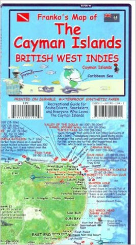
SIDE 1: The front side shows Grand Cayman as a separate map, and the Sister Islands, Little Cayman and Cayman Brac, together as another map. Each island is mapped in a unique style that shows the beauty of the island and the surrounding Caribbean Sea. Every detail of the coast can be clearly seen, along with a unique depiction of the bathymetry (underwater topography), so the viewer can visualize how the waters just beyond each islands shore plunges into the deep. This view helps the viewer to see how unusual the Cayman Islands really are, as they rise up from the deep to just above the surface. Map coloring shows you where it is green and covered by thick Cayman forest, or where it is a swampy mangrove, or where it is a city. All of the main roads, as well as a few trails are shown as well, so this is the perfect navigation map as you cruise around in your left-hand-drive rental car. This way of depicting islands on a map is new and unique (as are all Franko Maps), and the colors are truly beautiful, just as they are in real life. This map will inspire you to visit and return to the Cayman Islands because it shows you how absolutely beautiful they are. However, Frankos Map of The Cayman Islands is not just a pretty picture, but it is full of useful information as well. To start, there are descriptions of and dive flags locating Grand Caymans most notable dive spots, although the West End of Grand Cayman are detailed on side 2 of the map. There are over 150 dive sites shown just on Grand Cayman, and then well over 50 more on each of the Sister Islands. Since the number one activity of visitors to the Cayman Islands is diving and snorkeling, and since the underwater is so noteworthy and magnificent, this subject is destined to dominate the map. Many of the dive sites also include a few lines of descriptions to represent what might be seen on the dive site. Like other Franko Maps related to islands or coast areas, this map also depicts the 100 or so species of the local coral reef creatures that you will most likely see on any given dive or snorkeling excursion. Includes descriptions summarizing each island - one for Grand Cayman, one for Little Cayman, and one for Cayman Brac.
SIDE TWO - THE WEST END OF GRAND CAYMAN DETAIL: Again this map is colorful but in this case the color and the details are zoomed in. You cant quite see the turtles, but you can see the Cayman Turtle Farm. You cant quite see the boats, but the marinas and harbors are, and you can see where every resort is. Numerous captions detail the West End of Grand Cayman, which is the area that probably 90% of all Cayman Islands visitors see. This includes, of course, George Town, the capital of The Cayman Islands, and the main city with the most residents. It also details the fabulous Seven Mile Beach area, with every resort and hotel shown as if you are a mile above the Seven Mile Beach looking down on it. You can also see details like where shopping areas are, as well as a few favorite restaurants. Photos will never convey just how spectacular and beautiful the island and its shallow waters are as viewed from the air. On the north end of the West End of Grand Cayman is a drawing of the Cayman Wall from the surface, right at the Cobalt Coast.
- Product Number: 2171932M
- Product Code: FM_CAYMAN
- ISBN: 9781601901941
- Year of Publication: 2007
- Folded Size: 8.66 x 4.72 inches
- Unfolded Size: 24.8 x 18.5 inches
- Map type: Folded Map
- Geographical region: Cayman Islands


