
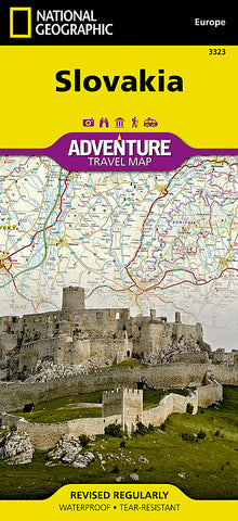


Slovakia Adventure Map 3323 by National Geographic Maps
• Waterproof • Tear-Resistant • Travel Map
National Geographics Slovakia Adventure Map is designed to meet the needs of adventure travelers with its detailed, accurate information and user-friendly design. Cities and towns are easy to find with the maps helpful index. Motorways, expressways, and other roads are clearly designated and include distance in kilometers so travelers can easily plan their best route. Specialty content such as hundreds of diverse and unique recreational, ecological, cultural, and historical destinations make Adventure Maps the perfect companion to a guidebook. Among the many diverse points of interest are museums, skifields, spas, viewpoints, campsites, zoos, archaeological sites, and more.
Slovakias snow-capped mountains and lush valleys making up almost a third of its area making it a great place for adventure whether you are on a solo holiday, travelling with a partner, or with a family group. Use side one to trek through the Alpine peaks of the High Tatras on the northern border with Poland. Afterward, explore some of central Europes largest castles, go underground to visit ethereal ice caves, and visit the marked UNESCO heritage sites. The reverse side will take you through Slovakias lively capital, Bratislava, and its charming Old Town. Explore the largely undeveloped countryside of northern Slovakia by bike, foot, or river barge.
Every Adventure Map is printed on durable synthetic paper, making them waterproof, tear-resistant and tough - capable of withstanding the rigors of international travel.
Map Scale = 1:295,000
- Product Number: 2127738M
- Product Code: NG_AM_SVK
- Publisher Product ID: AD00003323
- ISBN: 9781566956420
- Year of Publication: 2013
- Folded Size: 9.45 x 4.330 inches
- Unfolded Size: 24.8 x 32.68 inches
- Map type: Folded Map
- Geographical region: Miscellaneous


