
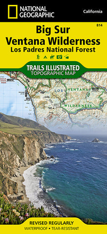


Big Sur, Ventana Wilderness and Los Padres Natl Forest, Map 814 by National Geographic Maps
• Waterproof • Tear-Resistant • Topographic Map
National Geographics Trails Illustrated map of Big Sur / Ventana Wilderness - Los Padres National Forest is a two-sided, waterproof map designed to meet the needs of outdoor enthusiasts with durability and detail. This map was created in conjunction with local land management agencies and is loaded with valuable recreation information.
The front side of Big Sur Ventana Wilderness map shows the south side of the area including Silver Peak Wilderness, Los Padres National Forest and Ventana Wilderness. The insets detail Ventana Wild Alliance, Los Padres National Forest, the US Forest Service campaign Tread Lightly, California State Parks, California Coastal National Monument, California Coastal Trail, outdoor ethics, contact information, conservation easements and land trusts, Monument Bay National Marie Sanctuary, and travel management and vehicle use. The reverse side of the map show the north side of the area, including Monterey Bay National Marine Sanctuary, Los Padres National Forest and Ventana Wilderness. The insets detail California State Parks and Pinnacles National Monument.
Trails Illustrated maps are expertly researched and frequently updated. The maps are printed in the United States on durable synthetic paper, making them waterproof, tear-resistant, and trail tough - capable of going anywhere you do.
- Product Number: 2060036M
- Product Code: TI_BIG_SUR
- Publisher Product ID: TI00000814
- ISBN: 9781566955782
- Year of Publication: 2012
- Folded Size: 9.45 x 4.330 inches
- Unfolded Size: 24.8 x 37.01 inches
- Map type: Folded Map
- Geographical region: California


