

Allagash Wilderness Waterway, North, Maine, Map 400 by National Geographic Maps
• Waterproof • Tear-Resistant • Topographic Map
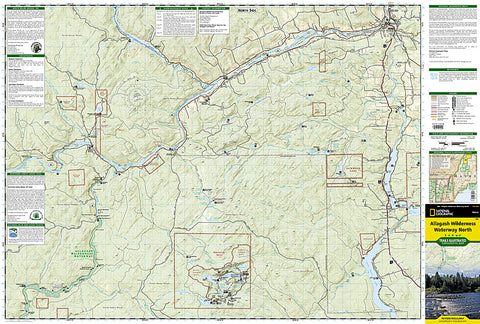
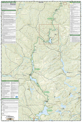
ALLAGASH WILDERNESS WATERWAY - NORTH Trails Illustrated Map
National Geographics recreational maps (TI 400 and 401) of the Allagash Wilderness Waterway are two-sided, waterproof maps designed to meet the needs of outdoor enthusiasts and tourists alike. Divided into two separate maps for exceptional detail, each is loaded with valuable information such as watercraft regulations, rules for recreational use and access, river difficulty scale, checkpoints, visitor and ranger station locations, and more. A UTM and Latitude/Longitude grid, as well as compass rose and scale bar will keep you pointed in the right direction.
Year-round activities abound in the region and the location of scenic viewpoints, wildlife viewing, boat launches and canoe carry downs, lookout towers, amphitheaters, ATV trails, and other points of interest are clearly marked as are park and forest boundaries and access points. Campers will appreciate the attention paid to noting the variety of camping facilities available including primitive campsites, group campsites, rental cabins, RV camping, picnic shelters, restrooms, parking, and trailheads. Whether paddling the Northern Forest Canoe Trail, camping in the North Maine Woods, or driving the Maine Scenic Byway, these maps perform as highly functional travel tools.
The Allagash Wilderness Waterway North map details the far northern reaches of the waterway on the Canadian border south to Churchill Lake. The front or north side of the map includes the area stretching from the Fort Kent State historic site on the Saint John River south to Saint Froid Lake. It also includes the Saint Francis, Fish, and Allagash Rivers, and the northern portion of Eagle Lake. The south side of the map shows Long Lake, Umsaskis Lake, the five Musquacook lakes, Spider Lake, and Pleasant Lake.
This Allagash Wilderness Waterway North map is printed in the U.S.A. on durable synthetic paper, making it waterproof, tear-resistant, and trail tough - capable of going anywhere you do.
- Product Number: 2053334M
- Product Code: TI_ALLAG_N
- Publisher Product ID: TI00000400
- ISBN: 9781566955867
- Year of Publication: 2011
- Folded Size: 9.45 x 4.330 inches
- Unfolded Size: 37.01 x 24.8 inches
- Map type: Folded Map
- Geographical region: Maine


