
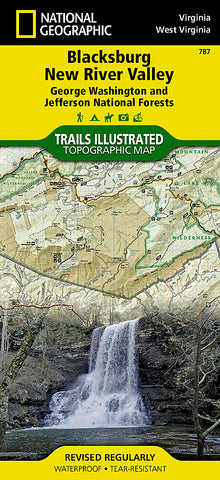
Blacksburg, New River Valley and Jefferson National Forest by National Geographic Maps
Outdoor enthusiasts seeking the bountiful recreational opportunities in southeastern Virginia will marvel at National Geographics Trails Illustrated map of Blacksburg and New River Valley. Expertly researched and created in cooperation with the U.S. Forest Service and others, the map delivers unparalleled detail of southern George Washington and Jefferson National Forests and the surrounding area from Brush Mountain East Wilderness in the northeast to Beartown Wilderness in the southwest. Also covered are Little Wolf Creek, Kimberling Creek, Garden Mountain, Brush Mountain, Mountain Lake, Peters Mountain and Hunting Camp Creek Wilderness areas.
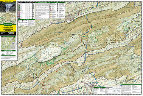
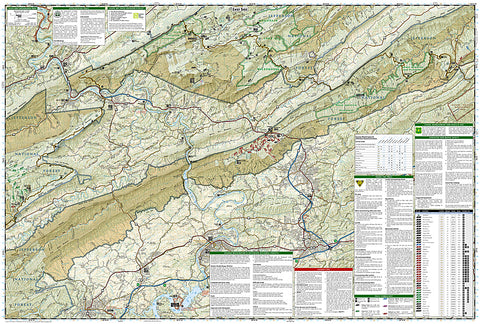
The maps activity and trail guides will help you select the most suitable location and route for your outdoor adventure according to your needs and interests. Trails are labeled for hiking, equestrian, mountain biking or motorized use. The Appalachian Trail that weaves through the area is shown with its shelters, parking areas and other facilities. To aid in your navigation, the map includes contour lines, elevations, labeled peaks and summits, water features, areas of wooded cover and selected waypoints. Those seeking a water adventure will find more than 70 miles of the New River mapped with mileage markers and labeled areas for boat launches, river access and swimming. Other recreation features pinpointed include campgrounds, rv campsites, public cabins, scenic overlooks and lookout towers, wildlife viewing areas and waterfalls.
Every Trails Illustrated map is printed on Backcountry Tough waterproof, tear-resistant paper. A full UTM grid is printed on the map to aid with GPS navigation.
Other features found on this map include: Blacksburg, Bluefield, Brushy Mountain, Christiansburg, Claytor Lake, East River, East River Mountain, Hunting Camp Creek Wilderness, Jefferson National Forest, Mountain Lake Wilderness, Poor Mountain, Sinking Creek, Walker Mountain.
- Product Number: 2034644M
- Product Code: TI_VA_BLACKSB
- Publisher Product ID: TI00000787
- ISBN: 9781566951166
- Year of Publication: 2001
- Folded Size: 9.45 x 4.33 inches
- Unfolded Size: 25.2 x 37.2 inches
- Map type: Folded Map
- Geographical region: Virginia


