
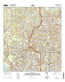
~ Citrus Park FL topo map, 1:24000 scale, 7.5 X 7.5 Minute, 2015
Citrus Park, Florida, USGS topographic map dated 2015.
Includes geographic coordinates (latitude and longitude). This topographic map is suitable for hiking, camping, and exploring, or framing it as a wall map.
Printed on-demand using high resolution imagery, on heavy weight and acid free paper, or alternatively on a variety of synthetic materials.
Topos available on paper, Waterproof, Poly, or Tyvek. Usually shipping rolled, unless combined with other folded maps in one order.
- Product Number: USGS-8002295
- Free digital map download (high-resolution, GeoPDF): Citrus Park, Florida (file size: 33 MB)
- Map Size: please refer to the dimensions of the GeoPDF map above
- Weight (paper map): ca. 55 grams
- Map Type: POD USGS Topographic Map
- Map Series: US Topo
- Map Verison: Current
- Cell ID: 8828
- Datum: North American Datum of 1983
- Map Projection: Transverse Mercator
- Map Cell Name: Citrus Park
- Grid size: 7.5 X 7.5 Minute
- Date on map: 2015
- Map Scale: 1:24000
- Geographical region: Florida, United States
Neighboring Maps:
All neighboring USGS topo maps are available for sale online at a variety of scales.
Spatial coverage:
Topo map Citrus Park, Florida, covers the geographical area associated the following places:
- West Park - Carrollwood South - Warren Estates - Oakmeadows West - Lake View Park - Carrillon Estates - Highland Park - Keystone Shores Estates - Westridge Village - Lane Farms - Ehrlich Gardenlands - Town Park - Copperfield - Arlington - Edgewater Place - Oak Trace - Ventana - Rocky Pond - Carrollwood Crossing - Fairway Village - White Trout Lake Shores - Shays Crest - Tropical Gardens - Plouff - Sandpiper - Huntington of Carrollwood - Stonegate - Woodbriar West - Pine Hollow - Green Grass Acres - Twelve Oaks Village - Oldsmar Farm - Mandolin - Shaw Place - Cypress Meadows - Carrollwood Springs - Brightside Village - Wildewood Village - North End Terrace - Bellefield Village - The Trails at Van Dyke Farms - Sunray Gardens - Turtle Crossing - West Park Estates - Byars Heights - Pine Terrace - Sugarwood Grove - J-R Manor - Cedarwood Village - Horseshoe Estates - Rocky Ford - Hidden Valley - Citrus Park - Parkwood Village - Enclave of Carrollwood - Levinson - Farmington - Andover Village - Waterstone - Indian Oaks - East Village - Country Club Village at Carrollwood - Paddock Trail - Pinecrest Villa - Pat Acres - Essex Downs - Mecca City - Northwest Park - Cypress Tree - Ansley Park - Westmont Oaks - Floraland Acres - Villas of San Marino at Carrollwood - Andover - Oakwood Villa - Lynn Lake - Greenbrook Village - Rock Lake - Hamilton Park - Country Place West - Triple Lake Shores - Hampton Park - Woodacre Estates of Northdale - Miralago Estates - Carrollwood Village - Cypress Willows - Stoneleigh - Quail Ridge North - Half Moon Tracts - Trafalgar Square - Arbor Ridge - Southern Comfort Homes - Waterfront Cove - Carrollwood Oaks - Heatherwood Village - Quail Ridge - Pennington Village - Americana - Himes Avenue Estates - Saint James
- Map Area ID: AREA28.12528-82.625-82.5
- Northwest corner Lat/Long code: USGSNW28.125-82.625
- Northeast corner Lat/Long code: USGSNE28.125-82.5
- Southwest corner Lat/Long code: USGSSW28-82.625
- Southeast corner Lat/Long code: USGSSE28-82.5
- Northern map edge Latitude: 28.125
- Southern map edge Latitude: 28
- Western map edge Longitude: -82.625
- Eastern map edge Longitude: -82.5


