
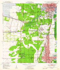
~ Fort Lauderdale South FL topo map, 1:24000 scale, 7.5 X 7.5 Minute, Historical, 1949
Fort Lauderdale South, Florida, USGS topographic map dated 1949.
Includes geographic coordinates (latitude and longitude). This topographic map is suitable for hiking, camping, and exploring, or framing it as a wall map.
Printed on-demand using high resolution imagery, on heavy weight and acid free paper, or alternatively on a variety of synthetic materials.
Topos available on paper, Waterproof, Poly, or Tyvek. Usually shipping rolled, unless combined with other folded maps in one order.
- Product Number: USGS-5624304
- Free digital map download (high-resolution, GeoPDF): Fort Lauderdale South, Florida (file size: 11 MB)
- Map Size: please refer to the dimensions of the GeoPDF map above
- Weight (paper map): ca. 55 grams
- Map Type: POD USGS Topographic Map
- Map Series: HTMC
- Map Verison: Historical
- Cell ID: 15939
- Scan ID: 346260
- Woodland Tint: Yes
- Aerial Photo Year: 1945
- Field Check Year: 1947
- Survey Year: 1945
- Datum: NAD27
- Map Projection: Polyconic
- Map published by United States Geological Survey
- Map published by United States Department of Commerce
- Map Language: English
- Scanner Resolution: 600 dpi
- Map Cell Name: Fort Lauderdale South
- Grid size: 7.5 X 7.5 Minute
- Date on map: 1949
- Map Scale: 1:24000
- Geographical region: Florida, United States
Neighboring Maps:
All neighboring USGS topo maps are available for sale online at a variety of scales.
Spatial coverage:
Topo map Fort Lauderdale South, Florida, covers the geographical area associated the following places:
- Oak Point - Boulevard Gardens - Port Everglades Junction - Orange Blossom Mobile Home Park - Hills Mobile Home Park - Grices Trailer Park - Dell Trailer Park - Parkway Mobile Home Court - Hitching Post Mobile Home Park - Crystal Lake Club Mobile Home Park - Dania Beach - Taylor's Trailer Park - Ponderosa Mobile Park - Avon Park - Weiners Mobile Home Park - Driftwood Acres - Moonlight Ranch Mobile Home Park - Fern Crest Village - Westgate Lake Manor - A and P Trailer Court - Pinecrest Mobile Home Park - Lazy Land Mobile Home Park - Davie - Lauderdale Harbors - Royal Garden Village Trailer Park - Pine Crest Mobile Home Park - Sheldon Mobile Home Court - Lauder Lakes Mobile Homes - Port Laudania - Playland Village - Hollywood - Swaying Palms Mobile Home Park - Pembroke Pines - Ramgoh Mobile Home Park - Port Everglades - Floridale Mobile Home Colony - Broward Gardens - Hollywood Beach Gardens - North Coast Trailer Park - Melrose Park - Evening Star Trailer Park - Ravenswood Estates - Driftwood Acres Mobile Park - Holland Mobile Home Park - New England Mobile Estates - Colony Mobile Home Park - Riverland - Ocean Waterway Mobile Home Park - David Zell Trailer Park - Azalea Trailer Colony Mobile Home Park - Fort Lauderdale - Chula Vista Isles - Broadview Park - Seminole Park Mobile Home Park - Playland Isles - Palma Nova Mobile Home Park - Plantation Isles - Pine Ridge Trailer Park - Aqua Isles Mobile Home Park - Fleetwood Manor - Lakes Park Mobile Home Park - Playland Estates - Okomo Mobile Home Park - Plantation Park - Twin Lakes Mobile Home Park - West Hollywood - Emerald Lakes Village Mobile Home Park - Driftwood Estates - Everglades Lakes Mobile Home Community - Sunshine Park - Hacienda Village - Lake Eden Gardens Mobile Home Park
- Map Area ID: AREA26.12526-80.25-80.125
- Northwest corner Lat/Long code: USGSNW26.125-80.25
- Northeast corner Lat/Long code: USGSNE26.125-80.125
- Southwest corner Lat/Long code: USGSSW26-80.25
- Southeast corner Lat/Long code: USGSSE26-80.125
- Northern map edge Latitude: 26.125
- Southern map edge Latitude: 26
- Western map edge Longitude: -80.25
- Eastern map edge Longitude: -80.125


