
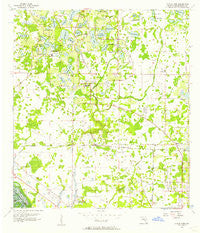
~ Citrus Park FL topo map, 1:24000 scale, 7.5 X 7.5 Minute, Historical, 1956, updated 1957
Citrus Park, Florida, USGS topographic map dated 1956.
Includes geographic coordinates (latitude and longitude). This topographic map is suitable for hiking, camping, and exploring, or framing it as a wall map.
Printed on-demand using high resolution imagery, on heavy weight and acid free paper, or alternatively on a variety of synthetic materials.
Topos available on paper, Waterproof, Poly, or Tyvek. Usually shipping rolled, unless combined with other folded maps in one order.
- Product Number: USGS-5622972
- Free digital map download (high-resolution, GeoPDF): Citrus Park, Florida (file size: 10 MB)
- Map Size: please refer to the dimensions of the GeoPDF map above
- Weight (paper map): ca. 55 grams
- Map Type: POD USGS Topographic Map
- Map Series: HTMC
- Map Verison: Historical
- Cell ID: 8828
- Scan ID: 345520
- Imprint Year: 1957
- Woodland Tint: Yes
- Aerial Photo Year: 1954
- Datum: NAD27
- Map Projection: Polyconic
- Map published by United States Geological Survey
- Map Language: English
- Scanner Resolution: 600 dpi
- Map Cell Name: Citrus Park
- Grid size: 7.5 X 7.5 Minute
- Date on map: 1956
- Map Scale: 1:24000
- Geographical region: Florida, United States
Neighboring Maps:
All neighboring USGS topo maps are available for sale online at a variety of scales.
Spatial coverage:
Topo map Citrus Park, Florida, covers the geographical area associated the following places:
- Mill Pond Village - Hudson Terrace - Lake Maurine Estates - Shaw Place - Mullis City - Spivey - Leto - Sunshine Village - North End Terrace - Andover Village - Frenchs - Carrollwood Cove - Stoneleigh - Northwest Park - Northrop Terrace - Fairway Village - Orange Blossom Creek - Reserve on Rock Lake - Meadow Brook - Mid Village - Galleria - Lowell Village - Woodmont - Green Grass Acres - Arlington Oaks - Fountain Park - Cypress Glen - Morganwoods Garden Homes - The Village South - Cypress Tree - Treehouses at Mohr Loop - Rocky Ford - Westchase - Arbor Oaks - Warren Estates - Estates of Rock Lake - Yent - Quail Ridge North - Southern Comfort Homes - Lakeshore - Citrus Acres - Cambridge Villas - Hibiscus Gardens - Levinson - Crestridge - Carrollwood Creek - Willowbrae Village - Beacon Meadows - Mohr Loop - Whirley Estates - Westmont Oaks - Northdale - Woodbriar West - Community Estates - Keystone Crossings - Twelve Oaks Village - Lake Maurine - Lake Crest Manor - Villas of San Marino at Carrollwood - Native Woods - Turtle Creek - Harr Estates - Oak View Terrace - Top of the Village - Citrus Pointe - Bradford - Carrollwood Reserve - Saint James - Himes Avenue Estates - George Road Estates - Hampton Park - Enclave of Carrollwood - Burnbrook - Waterstone - Citrus Park - Brentwood Park - Patterson Road - Lakeside Point - Town Park - Sheldon West Mobile Home Community - Hunters Glen - Steeplechase - Cedarwood Village - Stonegate - Lane Farms - Country Run - Creekside - Durango - Citrus Park Crossing - Rocky Creek - Cone Estates - Kirby Creek - West Park - Monaco Gardens - South Lake Shores - Paddock Trail - Villager Place - Rawls Road - Trafalgar Square - Lakeside Grove Estates
- Map Area ID: AREA28.12528-82.625-82.5
- Northwest corner Lat/Long code: USGSNW28.125-82.625
- Northeast corner Lat/Long code: USGSNE28.125-82.5
- Southwest corner Lat/Long code: USGSSW28-82.625
- Southeast corner Lat/Long code: USGSSE28-82.5
- Northern map edge Latitude: 28.125
- Southern map edge Latitude: 28
- Western map edge Longitude: -82.625
- Eastern map edge Longitude: -82.5


