
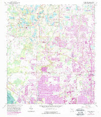
~ Citrus Park FL topo map, 1:24000 scale, 7.5 X 7.5 Minute, Historical, 1956, updated 1987
Citrus Park, Florida, USGS topographic map dated 1956.
Includes geographic coordinates (latitude and longitude). This topographic map is suitable for hiking, camping, and exploring, or framing it as a wall map.
Printed on-demand using high resolution imagery, on heavy weight and acid free paper, or alternatively on a variety of synthetic materials.
Topos available on paper, Waterproof, Poly, or Tyvek. Usually shipping rolled, unless combined with other folded maps in one order.
- Product Number: USGS-5622960
- Free digital map download (high-resolution, GeoPDF): Citrus Park, Florida (file size: 13 MB)
- Map Size: please refer to the dimensions of the GeoPDF map above
- Weight (paper map): ca. 55 grams
- Map Type: POD USGS Topographic Map
- Map Series: HTMC
- Map Verison: Historical
- Cell ID: 8828
- Scan ID: 345517
- Imprint Year: 1987
- Woodland Tint: Yes
- Photo Revision Year: 1987
- Aerial Photo Year: 1984
- Edit Year: 1987
- Survey Year: 1956
- Datum: NAD27
- Map Projection: Polyconic
- Map published by United States Geological Survey
- Map Language: English
- Scanner Resolution: 600 dpi
- Map Cell Name: Citrus Park
- Grid size: 7.5 X 7.5 Minute
- Date on map: 1956
- Map Scale: 1:24000
- Geographical region: Florida, United States
Neighboring Maps:
All neighboring USGS topo maps are available for sale online at a variety of scales.
Spatial coverage:
Topo map Citrus Park, Florida, covers the geographical area associated the following places:
- Carrollwood Preserve - Bellingham Oaks - Kirby Creek - Cedar Creek at Country Run - Cypress Run - Berkford Place - Carrollwood Cove - Lakeside Point - Saint Andrews Square - Citrus Acres - Morganwoods Garden Homes - Quail Ridge - Keystone Shores Estates - Hollyglen Village - Oak View Terrace - Citrus Pointe - West Waters Village - Byars Heights - Oakwood Villa - Fairfield Village - Wildewood Village - Sunray Gardens - Orange Blossom Creek - Green Grass Acres - Wingate Village - Lowell Village - Lake Julia - Indian Lakes - Rainbow Terrace - Bent Tree Place - Hampton Park - Turtle Creek - Eaglebrook - Fawn Ridge Village - Jasmine Pond - West Park Estates - Lake Crest Manor - Citrus Park Crossing - Woodmont - Sunray Estates - Belle Glen - Top of the Village - Pinehurst Villas - Stonegate - Keystone Acres - Himes Avenue Estates - Town Park - Country Run - Carrollwood Crossing - Yent - Woodbridge Park - Country Village - Heatherwood Village - Wood Lake - Arbor Lakes - Hamilton Park - Newport Landing - Plouff - Durango - Parkwood Village - Cedarwood Village - Sugarwood Grove - Tarpon - Ansley Park - Mohr Loop - Fairway Village - Glen Ellen Village - Mandolin - Triple Lake Shores - Mandarin Lakes - Eastbrook - Casa Blanca - Carrollwood Oaks - Sheldon West Mobile Home Community - Reserve at Woodmont - Fountain Park - Shadberry Village - Logan Place - Caseys Landing - Southern Comfort Homes - Cone Estates - Belle Glen Addition - Stoneleigh - Harr Estates - Lynn Lake - Four Score Manor - Arbor Oaks - Hidden Valley - Meadowglen - Town of Citrus Park - Edgewater Place - Village Wood - Floraland Acres - West Park - Springwood Village - Willowbrae Village - Le Clare Estates - O'Ryans Point on Half Moon Lake - North Village - Westchase
- Map Area ID: AREA28.12528-82.625-82.5
- Northwest corner Lat/Long code: USGSNW28.125-82.625
- Northeast corner Lat/Long code: USGSNE28.125-82.5
- Southwest corner Lat/Long code: USGSSW28-82.625
- Southeast corner Lat/Long code: USGSSE28-82.5
- Northern map edge Latitude: 28.125
- Southern map edge Latitude: 28
- Western map edge Longitude: -82.625
- Eastern map edge Longitude: -82.5


