
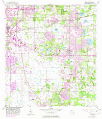
~ Brandon FL topo map, 1:24000 scale, 7.5 X 7.5 Minute, Historical, 1956, updated 1982
Brandon, Florida, USGS topographic map dated 1956.
Includes geographic coordinates (latitude and longitude). This topographic map is suitable for hiking, camping, and exploring, or framing it as a wall map.
Printed on-demand using high resolution imagery, on heavy weight and acid free paper, or alternatively on a variety of synthetic materials.
Topos available on paper, Waterproof, Poly, or Tyvek. Usually shipping rolled, unless combined with other folded maps in one order.
- Product Number: USGS-5622544
- Free digital map download (high-resolution, GeoPDF): Brandon, Florida (file size: 12 MB)
- Map Size: please refer to the dimensions of the GeoPDF map above
- Weight (paper map): ca. 55 grams
- Map Type: POD USGS Topographic Map
- Map Series: HTMC
- Map Verison: Historical
- Cell ID: 5263
- Scan ID: 345298
- Imprint Year: 1982
- Woodland Tint: Yes
- Photo Revision Year: 1981
- Aerial Photo Year: 1979
- Edit Year: 1981
- Survey Year: 1956
- Datum: NAD27
- Map Projection: Polyconic
- Map published by United States Geological Survey
- Map Language: English
- Scanner Resolution: 600 dpi
- Map Cell Name: Brandon
- Grid size: 7.5 X 7.5 Minute
- Date on map: 1956
- Map Scale: 1:24000
- Geographical region: Florida, United States
Neighboring Maps:
All neighboring USGS topo maps are available for sale online at a variety of scales.
Spatial coverage:
Topo map Brandon, Florida, covers the geographical area associated the following places:
- Oaklan - Williams Crossing - Eastlyn - Vineyards - Timber Pond - Eureka Homes - Waldrop Estates - Brandon Country Estates - Countryside Manor - Happy Acres - Morrill Meadows - Fernwood Terrace - Royal Oaks - Kingsway Downs - Hudson Estates - Oak Ridge Terrace - Casa de Sol - Van Sant - Amaya Estates - Wheeler Groves - Faulkenburg Heights - Las Brisas - Knifke Estates - Brentwood Hills - Brandon Crossroads - Barrington Oaks East - Sunway - Clair-Mel City - Four Winds Estates - Faith Park - Adamo Acres - Southern Oaks Grove - Orangeland - Quintessa - Ridge Dale - Pemberton Place - Colonial Oaks - Pavilion Phase 3 - Sylvia Manor - Kingwood Park - Palm River Park - Eastwood - Pine Landing Villas - Glen Oaks South - Belle Timbre - Progress Village - Wheeler Road - Oakbriar - Southwood Hills - Cien Fuegos - Oak Regency - Brower - Greenewood - Missouri Park - Kingswood Heights - Canterbury Lakes - Buffalo Estates - Harvest Field - Brandon - Murray Acres - Sterling Ranch - Burlington Heights - Kim Acres - Causeway Manor - Woodland Acres - Anselmi Acres - Brandon Estates - Pats - Val Villa - Parsons Reserve - Lake June Estates - Lake Marie Mobile Estates - Mango Hills - The Willows - Watermill at Providence Lakes - Lake Shore Ranch - Paka Estates - High Oaks Manor - Valrico Lake Estates - Buckhorn Creek - High Point Estates - Crestwood Estates - Hickory Woods - Woodmere Heights - Oakridge Manor - Lake Brandon - Brandon Groves - Carriage Crossing - Greenfield Terrace - Royal Crest Estates - Brandon Terrace Park - Tampa Tourist Club - Plantation Estates - Happy Homes - Hidden Forest - Brandon Oak Grove Estates - Big Pines - Brandon Park - Winchester Woods - Windhorst Village
- Map Area ID: AREA2827.875-82.375-82.25
- Northwest corner Lat/Long code: USGSNW28-82.375
- Northeast corner Lat/Long code: USGSNE28-82.25
- Southwest corner Lat/Long code: USGSSW27.875-82.375
- Southeast corner Lat/Long code: USGSSE27.875-82.25
- Northern map edge Latitude: 28
- Southern map edge Latitude: 27.875
- Western map edge Longitude: -82.375
- Eastern map edge Longitude: -82.25


