
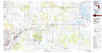
~ Fort Myers FL topo map, 1:100000 scale, 30 X 60 Minute, Historical, 1981, updated 1981
Fort Myers, Florida, USGS topographic map dated 1981.
Includes geographic coordinates (latitude and longitude). This topographic map is suitable for hiking, camping, and exploring, or framing it as a wall map.
Printed on-demand using high resolution imagery, on heavy weight and acid free paper, or alternatively on a variety of synthetic materials.
Topos available on paper, Waterproof, Poly, or Tyvek. Usually shipping rolled, unless combined with other folded maps in one order.
- Product Number: USGS-5621588
- Free digital map download (high-resolution, GeoPDF): Fort Myers, Florida (file size: 23 MB)
- Map Size: please refer to the dimensions of the GeoPDF map above
- Weight (paper map): ca. 55 grams
- Map Type: POD USGS Topographic Map
- Map Series: HTMC
- Map Verison: Historical
- Cell ID: 67535
- Scan ID: 346275
- Imprint Year: 1981
- Woodland Tint: Yes
- Aerial Photo Year: 1973
- Edit Year: 1981
- Datum: NAD27
- Map Projection: Universal Transverse Mercator
- Map published by United States Geological Survey
- Map Language: English
- Scanner Resolution: 600 dpi
- Map Cell Name: Fort Myers
- Grid size: 30 X 60 Minute
- Date on map: 1981
- Map Scale: 1:100000
- Geographical region: Florida, United States
Neighboring Maps:
All neighboring USGS topo maps are available for sale online at a variety of scales.
Spatial coverage:
Topo map Fort Myers, Florida, covers the geographical area associated the following places:
- Ridge Harbor - Flamingo Mobile Home Resort - Horizon Mobile Home Village - Palmdale - Windmill Village Mobile Home Park - The Heritage Mobile Home Park - Elizondos Trailer Park - Gilchrist - Ponderosa Mobile Home Park - LaBelle - Moore Haven Trailer Park - Blue Heron Pines - Buckingham - Lakes Park Mobile Home Community - Whidden Corner - Jamaica Bay West Mobile Home Park - Old Bridge Village Mobile Home Park - Swan Lake Mobile Home Village - Sans Souci - Poinsettia Mobile Home Park - Serendipity Mobile Home Park - Tropical Palms Mobile Home Park - Keri - Holbrook Trailer Park - Fox Mobile Home Park - Gateway - Fort Myers - Bayshore - Island Vista Estates Mobile Home Park - Holiday Acres Laynes 2 Mobile Home Park - Del Tura Country Club Mobile Home Park - Hall City - Tara Woods Mobile Home Park - Tuckers Corner - McGregor - Mere's Mobile Home Park - Goodno - Riverside Oaks Mobile Home Park - Alta Vista Park Mobille Home Park - Lazy Lagoon Mobile Park - Marion Mobile Home Park - Morse Shores - Whiskey Creek - River Trails Mobile Home Park - Orange Harbor Mobile Home Park - Orange Grove Mobile Home Park - Muce - Harrisburg - Sears - Kellys Trailer Park Number 1 - Tice Courts Mobile Home Park - Buccaneer Mobile Estates - Renaissance - Lakeville - Monkey Box - Caloosahatchee (historical) - Suncoast Estates - Fort Myers Shores - Washington Park - Salvista - Shell Creek Resort Mobile Home Park - Poinciana Estates - Page Mobile Home Village - Alva - Charleston Park - Harlem Heights - Julia Park Mobile Home Park - Ortona - Southern Villas Mobile Home Park - Las Palmas Mobile Home Park - Page Park - Jones Mobile Home Park - Benbow - Villas - Calusa Mobile Home Park - W D Trailer Park - Lehigh Acres - Telegraph Estates - Robert's Trailer Park - Royal Coach Village Mobile Home Park - Tropical Gulf Acres - Davis Trailer Park - Bayshore Village Mobile Home Park - Pine Manor - Fort Myers Villas - Bayshore Manor - Waterway Estates - Felda - Siesta Park Mobile Home Park - Palm and Pines Mobile Home Park - Cape Coral - Twin Pines Village Number 2 Mobile Home Park - Swifts Trailer Park - Slater - Denaud - Tropical Palms Trailer Park - Ventura Lakes Mobile Home Park - Iona - Olga - Shell Point Village
- Map Area ID: AREA2726.5-82-81
- Northwest corner Lat/Long code: USGSNW27-82
- Northeast corner Lat/Long code: USGSNE27-81
- Southwest corner Lat/Long code: USGSSW26.5-82
- Southeast corner Lat/Long code: USGSSE26.5-81
- Northern map edge Latitude: 27
- Southern map edge Latitude: 26.5
- Western map edge Longitude: -82
- Eastern map edge Longitude: -81


