
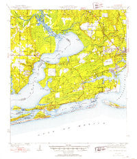
~ Fort Barrancas FL topo map, 1:62500 scale, 15 X 15 Minute, Historical, 1941
Fort Barrancas, Florida, USGS topographic map dated 1941.
Includes geographic coordinates (latitude and longitude). This topographic map is suitable for hiking, camping, and exploring, or framing it as a wall map.
Printed on-demand using high resolution imagery, on heavy weight and acid free paper, or alternatively on a variety of synthetic materials.
Topos available on paper, Waterproof, Poly, or Tyvek. Usually shipping rolled, unless combined with other folded maps in one order.
- Product Number: USGS-5621208
- Free digital map download (high-resolution, GeoPDF): Fort Barrancas, Florida (file size: 8 MB)
- Map Size: please refer to the dimensions of the GeoPDF map above
- Weight (paper map): ca. 55 grams
- Map Type: POD USGS Topographic Map
- Map Series: HTMC
- Map Verison: Historical
- Cell ID: 54250
- Scan ID: 346206
- Woodland Tint: Yes
- Edit Year: 1953
- Survey Year: 1941
- Datum: NAD27
- Map Projection: Polyconic
- Map published by United States Geological Survey
- Map published by United States Army Corps of Engineers
- Map Language: English
- Scanner Resolution: 600 dpi
- Map Cell Name: Fort Barrancas
- Grid size: 15 X 15 Minute
- Date on map: 1941
- Map Scale: 1:62500
- Geographical region: Florida, United States
Neighboring Maps:
All neighboring USGS topo maps are available for sale online at a variety of scales.
Spatial coverage:
Topo map Fort Barrancas, Florida, covers the geographical area associated the following places:
- Cerny Heights - Quinavista - Perdido Heights - Seaglades - Paradise Beach - Navy Point - Treasure Hill Park - Millview - Ramsey Beach - Perdido Key - Perdido Bay - Lillian - Avondale - Chanticleer - Johnsons Beach - Brownsville - Spanish Cove Mobile Home Park - Pleasant Grove - Warrington - Gulf Beach Heights - Bellview - Fort Pickens - Myrtle Grove - Haven Park - Beach Haven - Tristan Village - West Pensacola - Sherman Grove - Sand Cut
- Map Area ID: AREA30.530.25-87.5-87.25
- Northwest corner Lat/Long code: USGSNW30.5-87.5
- Northeast corner Lat/Long code: USGSNE30.5-87.25
- Southwest corner Lat/Long code: USGSSW30.25-87.5
- Southeast corner Lat/Long code: USGSSE30.25-87.25
- Northern map edge Latitude: 30.5
- Southern map edge Latitude: 30.25
- Western map edge Longitude: -87.5
- Eastern map edge Longitude: -87.25


