
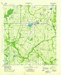
~ Wimauma FL topo map, 1:31680 scale, 7.5 X 7.5 Minute, Historical, 1944
Wimauma, Florida, USGS topographic map dated 1944.
Includes geographic coordinates (latitude and longitude). This topographic map is suitable for hiking, camping, and exploring, or framing it as a wall map.
Printed on-demand using high resolution imagery, on heavy weight and acid free paper, or alternatively on a variety of synthetic materials.
Topos available on paper, Waterproof, Poly, or Tyvek. Usually shipping rolled, unless combined with other folded maps in one order.
- Product Number: USGS-5621076
- Free digital map download (high-resolution, GeoPDF): Wimauma, Florida (file size: 8 MB)
- Map Size: please refer to the dimensions of the GeoPDF map above
- Weight (paper map): ca. 55 grams
- Map Type: POD USGS Topographic Map
- Map Series: HTMC
- Map Verison: Historical
- Cell ID: 49365
- Scan ID: 349136
- Woodland Tint: Yes
- Aerial Photo Year: 1942
- Datum: NAD27
- Map Projection: Polyconic
- Map published by United States Army Corps of Engineers
- Map published by United States Department of War
- Map Language: English
- Scanner Resolution: 600 dpi
- Map Cell Name: Wimauma
- Grid size: 7.5 X 7.5 Minute
- Date on map: 1944
- Map Scale: 1:31680
- Geographical region: Florida, United States
Neighboring Maps:
All neighboring USGS topo maps are available for sale online at a variety of scales.
Spatial coverage:
Topo map Wimauma, Florida, covers the geographical area associated the following places:
- Morris Park Farms - Arbors at Freedom Plaza - Carlton Branch - Pippin Farms - Pippins - Willow Shores - Cypress Park - Sun Lakes - Glengarry Green - Summerfield Wimauma - Nettlow - Camacho - Sweat Farms - Valencia Lakes - Puentes - Lake Wimauma - Balm Gardens - Saffold Estates - Scarboro - Wimauma - Willow - Southwind - Amberwave Estates - Cypressview - Kings - Orendain - Sun City Center - Lake View - Dell Vista - Little Manatee River Estates - Ventana North - Greenbriar - Gantree - The Knolls of Kings Point - Freedom Village - Bringers Saffold Ranchettes - Yorkshire - Pippin Estates - North Green Estates - Carmuchas - Club Manor - Caloosa - Riverranch Preserve - Stansell - West Green Estates - Jones - Flores - Caloosa Country Club Estates - Ranch Lands - West Lake Farms - Ramirez Estates
- Map Area ID: AREA27.7527.625-82.375-82.25
- Northwest corner Lat/Long code: USGSNW27.75-82.375
- Northeast corner Lat/Long code: USGSNE27.75-82.25
- Southwest corner Lat/Long code: USGSSW27.625-82.375
- Southeast corner Lat/Long code: USGSSE27.625-82.25
- Northern map edge Latitude: 27.75
- Southern map edge Latitude: 27.625
- Western map edge Longitude: -82.375
- Eastern map edge Longitude: -82.25


