Free Shipping on map orders over $300 - Prices in US$
Sitka Sound to Salisbury Sound, Inside Passage; Neva Str.-Neva Pt. to Zeal Pt. (17324-15) by NOAA
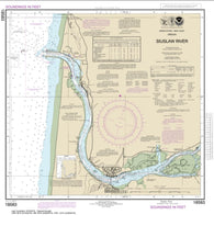
Siuslaw River (18583-40) by NOAA
Six Miles south of Stony Point to Port Bay; North Pond; Little Sodus Bay (14803-28) by NOAA
Sixteenmile Creek to Conneaut; Conneaut Harbor (14824-26) by NOAA
SKAGERRAK (305) by Kartverket
SKAGERRAK VESTRE BLAD (306) by Kartverket
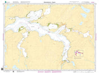
Skidegate Channel by Canadian Hydrographic Service
Skidegate Channel to/a Tian Rock by Canadian Hydrographic Service
SKJERSTADFJORDEN - ROGNAN (137) by Kartverket
Skull Cliff and vicinity (16083-7) by NOAA
Slocum and Limestone Inlets and Taku Harbor (17314-13) by NOAA
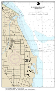
SMALL-CRAFT BOOK CHART - Chicago and South Shore of Lake Michigan (book of 30 charts) (14926-12) by NOAA
SMALL-CRAFT BOOK CHART - Detroit River, Lake St. Clair and St. Clair River (book of 47 charts) (14853-17) by NOAA
SMALL-CRAFT BOOK CHART - Inland Route, Cheboygan to Conway (book of 12 Charts) (14886-12) by NOAA
SMALL-CRAFT BOOK CHART - Lake Winnebago and Lower Fox River (book of 34 charts) (14916-10) by NOAA
SMALL-CRAFT BOOK CHART - Port Clinton to Sandusky, including the Islands (book of 35 charts) (14842-15) by NOAA
SMALL-CRAFT BOOK CHART - West End of Lake Erie from Perrysburg, OH., of the Maumee R. to Huron R., Mich., and Bar Pt., Ont. (book of 34 charts) (14846-14) by NOAA
SMALL-CRAFT BOOK CHART New York State Canal System (book of 61 Charts) (14786-14) by NOAA
Smith Inlet, Boswell Inlet and/et Draney Inlet by Canadian Hydrographic Service
Smith Island to/a Knight Harbour by Canadian Hydrographic Service
Smith Sound and/et Random Sound by Canadian Hydrographic Service
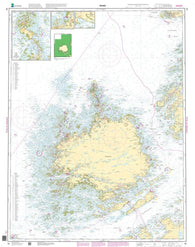
SMØLA (40) by Kartverket
Snake River-Lake Bryon (18547-8) by NOAA
Snake River-Lake Herbert G. West (18546-10) by NOAA
Snake River-Lower Granite Lake FRANKLIN D. ROOSEVELT LAKE (18548-5) by NOAA
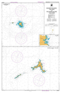
SNARES ISLANDS/TINI KEKE AND SOLANDER ISLAND (HAUTERE): HO HO BAY / (2411) by Land Information New Zealand (LINZ)
Snipe Bay to Crawfish Inlet,Baranof l. (17328-8) by NOAA
Snow Passage, Alaska (17383-3) by NOAA
Sodus Bay (14814-26) by NOAA
SOGNEFJORDEN. FRA FRESVIK TIL GUDVANGEN OG FLÅM (124) by Kartverket
SOGNESJÖEN - STAVENES (25) by Kartverket
Solomon Islands (Papua New Guinea And Solomon Sea) (NGA-82015-13) by National Geospatial-Intelligence Agency
Solomon Islands To Vanuatu (New Hebrides) (NGA-82020-7) by National Geospatial-Intelligence Agency
Sonoma Valley Wine Grapes Card by Frankos Maps Ltd.
Sooke by Canadian Hydrographic Service
Sooke Inlet to/a Parry Bay by Canadian Hydrographic Service
Sops Arm by Canadian Hydrographic Service
Sorel-Tracy a/to Varennes by Canadian Hydrographic Service
SÖRÖYSUND, STJERNSUND OG ROGNSUND (97) by Kartverket
Sound de Chausey by SHOM