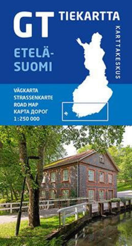
Finland South Karttakeskus Road Map
Southern Finland at 1:250,000 on a double-sided road map from Karttakeskus, the country’s national survey organization, with both topographic and extensive tourist information, including hotels, campsites, youth hostels, etc. Coverage includes Ahvenanmaa/Åland and the islands, and extends north to Tampere.
Maps in this series have detailed road classification, from dual carriageways to unsurfaced tracks and privately maintained roads, and indicate the widths of the single carriageway roads. Service and petrol stations are marked, and driving distances are shown on main and secondary routes. Railways are shown with stations and ferry routes are marked, as well as internal administrative boundaries and restricted access areas. The maps also include selected hiking routes and snowmobile tracks.
Topography is shown by contours at 20m intervals with spot heights, plus colouring and/or graphics indicate fields, woods, and marshes. Boundaries of national parks, conservation are
- Product Number: KART_S_FIN_20
- Reference Product Number: - None -
- ISBN: 9789522666697
- Date of Publication: 6/1/2020
- Folded Size: 8.26 inches high by 4.33 inches wide
- Unfolded (flat) Size: 33.46 inches high by 50.39 inches wide
- Map format: Folded
- Map type: Trade Maps - Road
- Geographical region: Finland