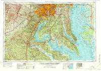
~ Washington DC topo map, 1:250000 scale, 1 X 2 Degree, Historical, 1957, updated 1971
Washington, District of Columbia, USGS topographic map dated 1957.
Includes geographic coordinates (latitude and longitude). This topographic map is suitable for hiking, camping, and exploring, or framing it as a wall map.
Printed on-demand using high resolution imagery, on heavy weight and acid free paper, or alternatively on a variety of synthetic materials.
Topos available on paper, Waterproof, Poly, or Tyvek. Usually shipping rolled, unless combined with other folded maps in one order.
- Product Number: USGS-5389870
- Free digital map download (high-resolution, GeoPDF): Washington, District of Columbia (file size: 25 MB)
- Map Size: please refer to the dimensions of the GeoPDF map above
- Weight (paper map): ca. 55 grams
- Map Type: POD USGS Topographic Map
- Map Series: HTMC
- Map Verison: Historical
- Cell ID: 69087
- Scan ID: 257789
- Imprint Year: 1971
- Woodland Tint: Yes
- Aerial Photo Year: 1952
- Edit Year: 1969
- Field Check Year: 1957
- Datum: Unstated
- Map Projection: Transverse Mercator
- Map published by United States Geological Survey
- Map Language: English
- Scanner Resolution: 600 dpi
- Map Cell Name: Washington
- Grid size: 1 X 2 Degree
- Date on map: 1957
- Map Scale: 1:250000
- Geographical region: District of Columbia, United States
Neighboring Maps:
All neighboring USGS topo maps are available for sale online at a variety of scales.
Spatial coverage:
Topo map Washington, District of Columbia, covers the geographical area associated the following places:
- Woods of Ilda - Patuxent Woods - Mount Zion - Sheckells Hills - Barcroft Woods - Bay Ridge Junction - Lakewood Estates - Saulsbury - Brown - Dailsville - Fairfax Woods - James - Stonehill Estates - Lynbrook - Riverdale Heights - Champlain - McHenry - Kings Crest - Queen Anne Colony - Old Sycamore Estates - Whiteley - Pagetts Corner - Bonfield - Beverley Mill - Kings Grant - Quiet Acres - Wallace Farms - Providence Cove - Japazaws - Cardinal Heights - Auburn - Scott Circle - Fair Vernon - Warburton Manor - Crown Manor - Long Beach - Covingtons Corner - Dudie - Rison - Waverly - Carters - Aveley - Briar Ridge - Independence Village - Marsh Run Estates - Unionville - White Hall - Lincoln Heights - Glen Alden - Friendship Woods - Pleasant Springs - Waynewood - Milton - Berry - Ardwick - Woolford - Melwood Mobile Home Park - Hillcrest Heights - Poplar Hill - Vernon Estates - Colonial Heights - Hope Acres - Dupont Park - Hunter - Battersea on the Bay - Patuxent River Estates - North Bend Woodland - Woodside View - Westminster - Tidwells - Olive - Annalee Heights - Bryantown - Dover - Oakland Acres - Biscoe - Marbury - Heather Hills - Oraville - Wellington Heights - Sutton Acres - Nomini Grove - Fairview - Lothian Woods - Claremont - Broyhill Park - Village of Mount Air - New Hampshire Gardens - Lakeview - Chapel Station - Tysons Green - The Cascades - Rosedale - Leitch - Mount Carmel - Knotsmythes Landing - Cedarwood - Georgetown East - Saint George Park - Hazelwood
- Map Area ID: AREA3938-78-76
- Northwest corner Lat/Long code: USGSNW39-78
- Northeast corner Lat/Long code: USGSNE39-76
- Southwest corner Lat/Long code: USGSSW38-78
- Southeast corner Lat/Long code: USGSSE38-76
- Northern map edge Latitude: 39
- Southern map edge Latitude: 38
- Western map edge Longitude: -78
- Eastern map edge Longitude: -76