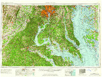
~ Washington DC topo map, 1:250000 scale, 1 X 2 Degree, Historical, 1961
Washington, District of Columbia, USGS topographic map dated 1961.
Includes geographic coordinates (latitude and longitude). This topographic map is suitable for hiking, camping, and exploring, or framing it as a wall map.
Printed on-demand using high resolution imagery, on heavy weight and acid free paper, or alternatively on a variety of synthetic materials.
Topos available on paper, Waterproof, Poly, or Tyvek. Usually shipping rolled, unless combined with other folded maps in one order.
- Product Number: USGS-5389866
- Free digital map download (high-resolution, GeoPDF): Washington, District of Columbia (file size: 23 MB)
- Map Size: please refer to the dimensions of the GeoPDF map above
- Weight (paper map): ca. 55 grams
- Map Type: POD USGS Topographic Map
- Map Series: HTMC
- Map Verison: Historical
- Cell ID: 69087
- Scan ID: 257786
- Woodland Tint: Yes
- Visual Version Number: 2
- Field Check Year: 1957
- Datum: Unstated
- Map Projection: Transverse Mercator
- Map published by United States Geological Survey
- Map Language: English
- Scanner Resolution: 600 dpi
- Map Cell Name: Washington
- Grid size: 1 X 2 Degree
- Date on map: 1961
- Map Scale: 1:250000
- Geographical region: District of Columbia, United States
Neighboring Maps:
All neighboring USGS topo maps are available for sale online at a variety of scales.
Spatial coverage:
Topo map Washington, District of Columbia, covers the geographical area associated the following places:
- Samuels Corner - Owings Hills - Westlake Village - Harwood - The Sands - Bald Eagle - New Hope Forest - Seat Pleasant - Courts at Stafford - Pilgrims Rest - Huntington - Dutchmans Cove - Westview Hills - Park Pines - Bel Air - Wallville - Pawpaw Hollow - The Plains - Forest Heights - Chinquapin Crest - Quantico - Norwood - Seabrook Acres - Baytowne Village - Wind Haven Estates - Burgundy Village - Holmehurst - Indian Head Manor - Chestnut Hills - Braddock Heights - Seven Corners - Moor Green Estates - Wetheridge Estates - Beechwood - Golden Hills - Lincoln - Pinefield - Arlington Heights - Longview Beach - Templeman - Bowers - Gatewood - Cedar Point - Tracys Landing - Hartlake Estates - Green Acres Estates - Deep Landing - Swan Villas - Seabreeze - Bishops Head - Mount Zion - Old Point Estates - Patuxent Mobile Estates - Hollin Hills - Port Republic - Edmonston - London Towne - Holly Corner - Lakeland - Lorfax Heights - Delaplane - Minnieville Estates - Seward - Saint Marys River Estates - Rustic Knolls - South River Spring Lakes - Gullwing Villas - North Cleveland Park - Kent Fort Manor - Queen Annes on Wye - Brookwood Estates - Montross - Swan Harbor - Sunderland Farms - Wellington Beach - Clearview - Hunters Square - Mount Harmony - Cliff Mills - Davis Corner - Adelphi Park - Turnbull - Villboro - Bywater Estates - Rosstown - Blue Oaks - Old Dominion Gardens - Double Oak Estates - Smiths Mill - Occoquan River Hills - Annandale Terrace - Poplar Hill - Yorkshire Knolls - Garden Estates - Hop Yard Landing - Fairland - Hollindale - Saint Leonard - Dupont Circle - Smith Lake Landing
- Map Area ID: AREA3938-78-76
- Northwest corner Lat/Long code: USGSNW39-78
- Northeast corner Lat/Long code: USGSNE39-76
- Southwest corner Lat/Long code: USGSSW38-78
- Southeast corner Lat/Long code: USGSSE38-76
- Northern map edge Latitude: 39
- Southern map edge Latitude: 38
- Western map edge Longitude: -78
- Eastern map edge Longitude: -76