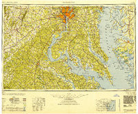
~ Washington DC topo map, 1:250000 scale, 1 X 2 Degree, Historical, 1948, updated 1951
Washington, District of Columbia, USGS topographic map dated 1948.
Includes geographic coordinates (latitude and longitude). This topographic map is suitable for hiking, camping, and exploring, or framing it as a wall map.
Printed on-demand using high resolution imagery, on heavy weight and acid free paper, or alternatively on a variety of synthetic materials.
Topos available on paper, Waterproof, Poly, or Tyvek. Usually shipping rolled, unless combined with other folded maps in one order.
- Product Number: USGS-5389862
- Free digital map download (high-resolution, GeoPDF): Washington, District of Columbia (file size: 21 MB)
- Map Size: please refer to the dimensions of the GeoPDF map above
- Weight (paper map): ca. 55 grams
- Map Type: POD USGS Topographic Map
- Map Series: HTMC
- Map Verison: Historical
- Cell ID: 69087
- Scan ID: 257784
- Imprint Year: 1951
- Woodland Tint: Yes
- Aerial Photo Year: 1944
- Datum: NAD27
- Map Projection: Transverse Mercator
- Map published by United States Army Corps of Engineers
- Map published by United States Army
- Map published by United States Department of War
- Map Language: English
- Scanner Resolution: 600 dpi
- Map Cell Name: Washington
- Grid size: 1 X 2 Degree
- Date on map: 1948
- Map Scale: 1:250000
- Geographical region: District of Columbia, United States
Neighboring Maps:
All neighboring USGS topo maps are available for sale online at a variety of scales.
Spatial coverage:
Topo map Washington, District of Columbia, covers the geographical area associated the following places:
- Bowie - Locks Corner - Peacock Station - Monastery Lot (historical) - Avon Forest - Chapel View - Pendleton - Midway Estates - Lorfax Heights - Brookland - Simmons Acres - Michigan Park Hills - Broyhill-McLean Estates - Brookville - Constitution Hills - Friendly Pines - Fishing Creek Farms - Hartwood - Fayettesville - Whitetown - Sunnyside - Blaisdell Subdivision - McConchie - Mallard Point - Yendor Landing - Trails End Trailer Park - Widewater - Bon Haven - Eagle Harbor - Churchill - Crystal Springs - Eastport - Winchester Estates - Thompson Corner - Shamrock Glen Estates - Keene Mill Heights - North Takoma Park - Chatham Village - Castle Marina - Crestwood Manor - Fosters Mobile Home Park - Bunker Hill - Oxon Hill - White Landing - Monticello Woods - Bethlehem Fork - Jackson Landing - Wakefield - Centreville Farms - Brynwood Farm Estates - Montyville Estates - Deerfield Estates - West Woods - Petworth - West Lanham Hills - Brookhaven - Old Point Estates - Belvedere Woodland - Mecklenburg - Casanova - Martingham - Cherry Hill Estates - Woodland - Fairfax Woods - Oak Estates - Waldorf - Lowrys Resurvey - Cove View - Indianbone - Melwood Mobile Home Park - Glenora - Goldvein - Batna - Forest Grove - Clearview Heights - Tompkinsville - Forest Park - Raintree - Randle Highlands - Broad Run Village - Mica - Green Valley - Saint Aubins Heights - Lincoln Heights - Rosecroft - Montaine - Higgins - North Keys - Vannoy Park - Robeys Mill - Yates Village - Hidden River - West Riverdale - Colonial Port - Mill Hill Estates - Friendly Hills - Churchill - Maple Hills - Pipetown (historical) - Rosslyn
- Map Area ID: AREA3938-78-76
- Northwest corner Lat/Long code: USGSNW39-78
- Northeast corner Lat/Long code: USGSNE39-76
- Southwest corner Lat/Long code: USGSSW38-78
- Southeast corner Lat/Long code: USGSSE38-76
- Northern map edge Latitude: 39
- Southern map edge Latitude: 38
- Western map edge Longitude: -78
- Eastern map edge Longitude: -76