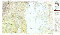
~ Washington East DC topo map, 1:100000 scale, 30 X 60 Minute, Historical, 1983, updated 1984
Washington East, District of Columbia, USGS topographic map dated 1983.
Includes geographic coordinates (latitude and longitude). This topographic map is suitable for hiking, camping, and exploring, or framing it as a wall map.
Printed on-demand using high resolution imagery, on heavy weight and acid free paper, or alternatively on a variety of synthetic materials.
Topos available on paper, Waterproof, Poly, or Tyvek. Usually shipping rolled, unless combined with other folded maps in one order.
- Product Number: USGS-5389852
- Free digital map download (high-resolution, GeoPDF): Washington East, District of Columbia (file size: 27 MB)
- Map Size: please refer to the dimensions of the GeoPDF map above
- Weight (paper map): ca. 55 grams
- Map Type: POD USGS Topographic Map
- Map Series: HTMC
- Map Verison: Historical
- Cell ID: 68549
- Scan ID: 257714
- Imprint Year: 1984
- Woodland Tint: Yes
- Aerial Photo Year: 1981
- Edit Year: 1983
- Datum: NAD27
- Map Projection: Universal Transverse Mercator
- Map published by United States Geological Survey
- Map Language: English
- Scanner Resolution: 600 dpi
- Map Cell Name: Washington East
- Grid size: 30 X 60 Minute
- Date on map: 1983
- Map Scale: 1:100000
- Geographical region: District of Columbia, United States
Neighboring Maps:
All neighboring USGS topo maps are available for sale online at a variety of scales.
Spatial coverage:
Topo map Washington East, District of Columbia, covers the geographical area associated the following places:
- Pindell - Blandford Village - Queen Annes Acres - Fox Chapel - Primrose Acres - Pin Oak Village - Calvert Manor - Westelee - Hickory Ridge - Deer Park Heights - North Beach - Brynwood Farm Estates - Capitol Heights - Chapel Hill - D'Arcy Hills - Belle Point Farm - River Bend Estates - Friends Choice - White House Heights - Horsehead - Hawthorne Woods - Baytowne Village - Peach Blossom Farm - Hallmark Estates - Paris Estates - Queen Anne - Bright Acres Mobile Home Park - Oaklawn - Greenwood Acres - Homewood - Fairview Estates - Penwick Village - Edgewood Terrace - Friendship Woods - Tanglewood - Lower Marlboro - Cottage City - Woodland - Riva - Shady Side - Rutland - Rives - Potts Point - West Galloway - Oakwood - Keys Farm - Smallet Manor - Kaywood Gardens - Greenwood Manor - Wye Landing - Canonbury Square - Prince Frederick - Jacktown - Lahaina - Riverview Manor - Simpsons Farm - Calverton - Bladen - Pendleton - Carole Highlands - Parvilla - Claibornes Landing - Silver Hill Park - Deep Harbour Farm Estates - Huntington Townhouses - Brelsmir Haven - Mulberry Point - Admiral Heights - Shoreham Beach - Dupont Heights - Northwood - Green Meadows - Tippett - Huntingfields Manor - North River Forest - Forest Grove - Paris - Karen Knolls - Holly Oaks - Sylvanhurst - Pagetts Corner - The Bachelor Point Harbor - Brentwood - Mitchellville - West Lanham Hills - Bell - Underwood (historical) - Warrlinda - Fairbank - Rio Vista Plaza Mobile Home Park - Nutwell - Rolling Acres - Edgeview - Bonfield - Rogers Heights - Springhill - Hillsmere Estates - Browns Corner - Sudleys Choice - Pine Grove Estates
- Map Area ID: AREA3938.5-77-76
- Northwest corner Lat/Long code: USGSNW39-77
- Northeast corner Lat/Long code: USGSNE39-76
- Southwest corner Lat/Long code: USGSSW38.5-77
- Southeast corner Lat/Long code: USGSSE38.5-76
- Northern map edge Latitude: 39
- Southern map edge Latitude: 38.5
- Western map edge Longitude: -77
- Eastern map edge Longitude: -76