
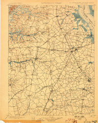
~ Dover DE topo map, 1:125000 scale, 30 X 30 Minute, Historical, 1899
Dover, Delaware, USGS topographic map dated 1899.
Includes geographic coordinates (latitude and longitude). This topographic map is suitable for hiking, camping, and exploring, or framing it as a wall map.
Printed on-demand using high resolution imagery, on heavy weight and acid free paper, or alternatively on a variety of synthetic materials.
Topos available on paper, Waterproof, Poly, or Tyvek. Usually shipping rolled, unless combined with other folded maps in one order.
- Product Number: USGS-5390384
- Free digital map download (high-resolution, GeoPDF): Dover, Delaware (file size: 8 MB)
- Map Size: please refer to the dimensions of the GeoPDF map above
- Weight (paper map): ca. 55 grams
- Map Type: POD USGS Topographic Map
- Map Series: HTMC
- Map Verison: Historical
- Cell ID: 65368
- Scan ID: 255747
- Survey Year: 1896
- Datum: Unstated
- Map Projection: Unstated
- Map published by United States Geological Survey
- Map Language: English
- Scanner Resolution: 600 dpi
- Map Cell Name: Dover
- Grid size: 30 X 30 Minute
- Date on map: 1899
- Map Scale: 1:125000
- Geographical region: Delaware, United States
Neighboring Maps:
All neighboring USGS topo maps are available for sale online at a variety of scales.
Spatial coverage:
Topo map Dover, Delaware, covers the geographical area associated the following places:
- Petersburg - Voshell Mill - Green Briar - Cash Corner (historical) - Deans Meadows - Kennedyville - Viola - Rehak - Leipsic - Townsend - Fairview - Huntley - Middletown - Long Point Landing - Choptank Mills - Lyn Woods - Cleavers Corner - Sunnyside Village - Del Haven Estates - Cronshaw - Beech Haven - Lower Moores Corner - Shorts Corner - Four Seasons - Pennwood - Bishops Corner - Rising Sun - Double Creek Wood - Johnson Farm - Whigville - Hartly - Woodbury - Spry Landing - Sunset Point - Lawndale - White Hall - Ruthsburg - Holletts Corners - Barclay Farms - Lone Star Mobile Home Park - Seven Hickories - Rolling Meadows - Royal Grant - Bethesda - Lexington Mill - Sugar Loaf Chase - Kirby Landing - Sagefield - Hay Point Landing - Hidden Acres - Scotchmans Glen - Forrest Grove Village Mobile Home Park - John Town - Felton Manor - Dinahs Corner - Ford Landing - Pleasant Hill - Slaughter - Great Oak Farms - Persimmon Park Place - Dutch Neck Crossroads - Bethel - Rivers Edge - Kent Acres - Plymouth - The Orchard - Cardinal Hills - Locust Grove - Mallard Pond - Lebanon - Coopers Corner - Huntley Circle - Beades Estate - Earleville - Piney Ridge - Smith Crossroads - Bolton - Morris Estates - Goldsborough (historical) - Fords Corner - Felton - Stevens Corner - Maplehurst - Mussel Shoals - Cleaves Fork - Hayden - Woodcrest - Woodstock Court - Kane Crossroads - Moores Corner - Hazelwood - Sheriden - Sandtown - Bechers Brook - Pleasanton Acres - Kentbourne II - Lakewind III - Planters Woods - Winmill - Armstrong
- Map Area ID: AREA39.539-76-75.5
- Northwest corner Lat/Long code: USGSNW39.5-76
- Northeast corner Lat/Long code: USGSNE39.5-75.5
- Southwest corner Lat/Long code: USGSSW39-76
- Southeast corner Lat/Long code: USGSSE39-75.5
- Northern map edge Latitude: 39.5
- Southern map edge Latitude: 39
- Western map edge Longitude: -76
- Eastern map edge Longitude: -75.5


