
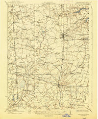
~ Harrington DE topo map, 1:62500 scale, 15 X 15 Minute, Historical, 1918, updated 1938
Harrington, Delaware, USGS topographic map dated 1918.
Includes geographic coordinates (latitude and longitude). This topographic map is suitable for hiking, camping, and exploring, or framing it as a wall map.
Printed on-demand using high resolution imagery, on heavy weight and acid free paper, or alternatively on a variety of synthetic materials.
Topos available on paper, Waterproof, Poly, or Tyvek. Usually shipping rolled, unless combined with other folded maps in one order.
- Product Number: USGS-5390320
- Free digital map download (high-resolution, GeoPDF): Harrington, Delaware (file size: 6 MB)
- Map Size: please refer to the dimensions of the GeoPDF map above
- Weight (paper map): ca. 55 grams
- Map Type: POD USGS Topographic Map
- Map Series: HTMC
- Map Verison: Historical
- Cell ID: 55085
- Scan ID: 255758
- Imprint Year: 1938
- Survey Year: 1917
- Datum: NAD
- Map Projection: Polyconic
- Map published by United States Geological Survey
- Map published by United States Army Corps of Engineers
- Map published by United States Department of War
- Map Language: English
- Scanner Resolution: 600 dpi
- Map Cell Name: Harrington
- Grid size: 15 X 15 Minute
- Date on map: 1918
- Map Scale: 1:62500
- Geographical region: Delaware, United States
Neighboring Maps:
All neighboring USGS topo maps are available for sale online at a variety of scales.
Spatial coverage:
Topo map Harrington, Delaware, covers the geographical area associated the following places:
- McKnatt Corners - Lake Forest Mobile Home Est - Vernon - Farmington - Houston - Cocked Hat - Six Forks - Fleming Corners - Pine Ridge - Schultie Crossroads - Whiteleysburg - Harrington - Warrington Manor - Hopkins Corners - Bridgeville North - Hughes Crossroads - Argos Choice - Owens - Whiteleysburg - Williamsville - Powelton - Jacksons Ridge - Minners Corners - Newton Woods - Greenville - Woodenhawk - Roesville - Reeves Crossing - Bloomfield Acres - Scotts Corner - Paris Woods - John Char Estates - Dublin Hill - Melvin Crossroads - Greenwood Gardens - Hollandsville - Fernwood - Pleasant Woods - D and K Mobile Home Park - Hickman - Bloomery - Smithville - Deer Creek - Melvins - Andrewsville - Adams Crossroads - Hickory Ridge - Staytonville - Greenwood - Layton Corners - Edwardsville - Hickman - Adamsville - Saint Johnstown - Burrsville - Lucky Estates - Marvels Crossroads - Circle Haven Mobile Home Park - Woodenhawk Pines - Brownsville - Mastens Corner - I and I Mobile Home Park - Blanchard - Greens Corner - Big Pine - Melvins Crossroads - Union Corners
- Map Area ID: AREA3938.75-75.75-75.5
- Northwest corner Lat/Long code: USGSNW39-75.75
- Northeast corner Lat/Long code: USGSNE39-75.5
- Southwest corner Lat/Long code: USGSSW38.75-75.75
- Southeast corner Lat/Long code: USGSSE38.75-75.5
- Northern map edge Latitude: 39
- Southern map edge Latitude: 38.75
- Western map edge Longitude: -75.75
- Eastern map edge Longitude: -75.5


