
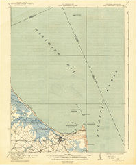
~ Cape Henlopen DE topo map, 1:62500 scale, 15 X 15 Minute, Historical, 1937, updated 1943
Cape Henlopen, Delaware, USGS topographic map dated 1937.
Includes geographic coordinates (latitude and longitude). This topographic map is suitable for hiking, camping, and exploring, or framing it as a wall map.
Printed on-demand using high resolution imagery, on heavy weight and acid free paper, or alternatively on a variety of synthetic materials.
Topos available on paper, Waterproof, Poly, or Tyvek. Usually shipping rolled, unless combined with other folded maps in one order.
- Product Number: USGS-5390304
- Free digital map download (high-resolution, GeoPDF): Cape Henlopen, Delaware (file size: 5 MB)
- Map Size: please refer to the dimensions of the GeoPDF map above
- Weight (paper map): ca. 55 grams
- Map Type: POD USGS Topographic Map
- Map Series: HTMC
- Map Verison: Historical
- Cell ID: 52134
- Scan ID: 255736
- Imprint Year: 1943
- Survey Year: 1917
- Datum: NAD
- Map Projection: Polyconic
- Map published by United States Geological Survey
- Map published by United States Army Corps of Engineers
- Map published by United States Department of War
- Map Language: English
- Scanner Resolution: 600 dpi
- Map Cell Name: Cape Henlopen
- Grid size: 15 X 15 Minute
- Date on map: 1937
- Map Scale: 1:62500
- Geographical region: Delaware, United States
Neighboring Maps:
All neighboring USGS topo maps are available for sale online at a variety of scales.
Spatial coverage:
Topo map Cape Henlopen, Delaware, covers the geographical area associated the following places:
- Dutch Acres - Pilottown - Carsylian Acres - Millpond Acres - Mill Pond Acres - Nassau - Lewes Beach - Heronwood - Cripple Creek - McNichol Place - Shady Side - Green Hill - Primehook Beach - Black Hog Landing - Houston - Hazzard Landing - Sand Dunes Village - Oyster Rocks - Highland Acres - Capes Cove Mobile Home Park - Shaffer Property - Donovan Development - Red Hill Manor - Mill Creek Manor - Star Landing - Highland Acres - Lewes - Covey Creek - Wescoats Corner - Quakertown - Murrays Corner - Quakers Heights - Swanendael - Broadkill Beach - Edgewater - Wiltbank Landing - Robertson Landing - Overbrook - Overbrook Shores - Savannah Place - Steamboat Landing - Sweet Briar Mobile Home Park - East Mill Run
- Map Area ID: AREA3938.75-75.25-75
- Northwest corner Lat/Long code: USGSNW39-75.25
- Northeast corner Lat/Long code: USGSNE39-75
- Southwest corner Lat/Long code: USGSSW38.75-75.25
- Southeast corner Lat/Long code: USGSSE38.75-75
- Northern map edge Latitude: 39
- Southern map edge Latitude: 38.75
- Western map edge Longitude: -75.25
- Eastern map edge Longitude: -75


