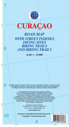
Curaçao : road map with street indexes diving sites biking trails and hiking trails
Curaçao at 1:55,000 on an indexed and GPS compatible map from the Caribbean-based cartographer Michal Kasprowski highlighting numerous diving sites and various places of interest, with street plans of four locations plus on the reverse a more detailed enlargement of the Willemstad urban area.
Topography is shown by altitude colouring with spot heights; the Christoffel National Parks is clearly marked. Road network indicates main roads and shows secondary roads and local tracks or footpaths. Recommended biking and hiking trails are highlighted. Symbols show various facilities and places of interest including beaches and snorkelling sites, flamingo areas, scenic views, etc. Along the coast numerous diving sites are marked. The map has latitude and longitude lines at 2’ intervals. The index lists road/street names. Map legend is in English.
On the reverse is an indexed enlargement showing in greater detail at 1:18,500 the Willemstad urban area, including access to the isla
- Product Number: KAS_CUR_16
- Reference Product Number: 2226214M
- ISBN: 9791095793038
- Date of Publication: 6/1/2016
- Folded Size: 9.06 inches high by 4.72 inches wide
- Unfolded (flat) Size: 38.58 inches high by 26.38 inches wide
- Map format: Folded
- Map type: Trade Maps - Road
- Geographical region: Curacao