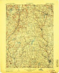
~ Litchfield CT topo map, 1:125000 scale, 30 X 30 Minute, Historical, 1904
Litchfield, Connecticut, USGS topographic map dated 1904.
Includes geographic coordinates (latitude and longitude). This topographic map is suitable for hiking, camping, and exploring, or framing it as a wall map.
Printed on-demand using high resolution imagery, on heavy weight and acid free paper, or alternatively on a variety of synthetic materials.
Topos available on paper, Waterproof, Poly, or Tyvek. Usually shipping rolled, unless combined with other folded maps in one order.
- Product Number: USGS-8506677
- Free digital map download (high-resolution, GeoPDF): Litchfield, Connecticut (file size: 10 MB)
- Map Size: please refer to the dimensions of the GeoPDF map above
- Weight (paper map): ca. 55 grams
- Map Type: POD USGS Topographic Map
- Map Series: HTMC
- Map Verison: Historical
- Cell ID: 65911
- Scan ID: 331215
- Survey Year: 1890
- Datum: Unstated
- Map Projection: Unstated
- Map published by United States Geological Survey
- Map Language: English
- Scanner Resolution: 600 dpi
- Map Cell Name: Litchfield
- Grid size: 30 X 30 Minute
- Date on map: 1904
- Map Scale: 1:125000
- Geographical region: Connecticut, United States
Neighboring Maps:
All neighboring USGS topo maps are available for sale online at a variety of scales.
Spatial coverage:
Topo map Litchfield, Connecticut, covers the geographical area associated the following places:
- Lanesville - Cornwall Bridge - Westview Heights - Bantam - Pomeraug - Northville - Tolles - East Morris - Riverview Mobile Home Estates - Torringford - Nelsons Corner - Sharon Valley - Hillcrest - Joyceland (historical) - North Woodbury - Park Lane - Newberry Corner - Long Hill - Horse Heaven - Hotchkissville - West Woods - Roxbury - Marble Dale - Campville - Reynolds Bridge - Oronoke - Candlewood Springs - Woodbury - Fair Lawn - East Mountain - West Goshen - Winsted - Bridgewater - Macedonia - Goshen - Lime Rock - West Torrington - Atchison Cove - Winchester Center - Warren - Emmons City (historical) - Norfolk - Chimney Point - Mooreville - Romford - Town Plot Hill - Greystone - Acropolis (historical) - Middlebury - Litchfield - Watertown - South Canaan - Kent - Harwinton - Waterbury - Wrightville - Kelly Corner - Hancock - Fairmount - Milton - Corner of the Pines - New Milford - Gaylordsville - West Cornwall - Sherman - Bradleyville - Lakeville - New Preston - Tyler Lake Heights - Mitcheltown - Interlaken Estates - Sandy Beach - Grantville - Mill Plain - Lakeside - Bethlehem - Falls Village - Washington - Candlewood Point - Colebrook - Ellsworth - South Ellsworth - East Litchfield - Upper Merryall - Grappaville - Morris - Kent Furnace - Huntsville - Calhoun Corners - Dempsey Landing - Newfield - Robertsville - Turkey Cobble - Erickson Corner - Woodville - Roxbury Station - Roxbury Falls - South Kent - Flanders - Waterville
- Map Area ID: AREA4241.5-73.5-73
- Northwest corner Lat/Long code: USGSNW42-73.5
- Northeast corner Lat/Long code: USGSNE42-73
- Southwest corner Lat/Long code: USGSSW41.5-73.5
- Southeast corner Lat/Long code: USGSSE41.5-73
- Northern map edge Latitude: 42
- Southern map edge Latitude: 41.5
- Western map edge Longitude: -73.5
- Eastern map edge Longitude: -73