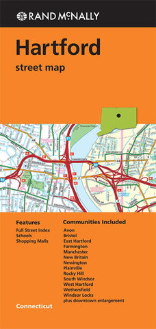
Hartford, Connecticut by Rand McNally
Rand McNallys folded map for Hartford is a must-have for anyone traveling in and around this part of Connecticut, offering unbeatable accuracy and reliability at a great price. Trusted cartography shows all Interstate, U.S., state, and county highways, along with clearly indicated parks, points of interest, airports, county boundaries, and streets. The easy-to-use legend and detailed index make for quick and easy location of destinations. Youll see why Rand McNally folded maps have been the trusted standard for years.
Regularly updated
Full-color maps
Clearly labeled Interstate, U.S., state, and county highways
Indications of parks, points of interest, airports, county boundaries, schools, shopping malls, downtown & vicinity maps
Enlargements of downtown
Easy-to-use legend
Detailed index & full street index
Convenient folded size
© 2013
Communities Included: Avon, Bristol, East Hartford, Farmington, Manchester, New Britain, Newington, Plainville, Rocky Hill, South Windsor, West Hartford, Wethersfield, Windsor Locks
- Product Number: 2154601M
- Product Code: RM_HARTFORD
- ISBN: 9780528008238
- Year of Publication: 2013
- Folded Size: 9.06 x 4.33 inches
- Unfolded Size: 38.58 x 26.77 inches
- Map type: Folded Map
- Geographical region: Connecticut