
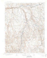
~ Uncompahgre CO topo map, 1:125000 scale, 30 X 30 Minute, Historical, 1911, updated 1944
Uncompahgre, Colorado, USGS topographic map dated 1911.
Includes geographic coordinates (latitude and longitude). This topographic map is suitable for hiking, camping, and exploring, or framing it as a wall map.
Printed on-demand using high resolution imagery, on heavy weight and acid free paper, or alternatively on a variety of synthetic materials.
Topos available on paper, Waterproof, Poly, or Tyvek. Usually shipping rolled, unless combined with other folded maps in one order.
- Product Number: USGS-5359649
- Free digital map download (high-resolution, GeoPDF): Uncompahgre, Colorado (file size: 6 MB)
- Map Size: please refer to the dimensions of the GeoPDF map above
- Weight (paper map): ca. 55 grams
- Map Type: POD USGS Topographic Map
- Map Series: HTMC
- Map Verison: Historical
- Cell ID: 66836
- Scan ID: 402379
- Imprint Year: 1944
- Survey Year: 1908
- Datum: NAD
- Map Projection: Polyconic
- Map published by United States Geological Survey
- Map Language: English
- Scanner Resolution: 508 dpi
- Map Cell Name: Uncompahgre
- Grid size: 30 X 30 Minute
- Date on map: 1911
- Map Scale: 1:125000
- Geographical region: Colorado, United States
Neighboring Maps:
All neighboring USGS topo maps are available for sale online at a variety of scales.
Spatial coverage:
Topo map Uncompahgre, Colorado, covers the geographical area associated the following places:
- Cathedral - Smith Place - Gateview - Powderhorn - Sapinero - Henson - Capitol City (historical) - Iola (historical) - Midway (historical) - Vulcan (historical) - Lake City
- Map Area ID: AREA38.538-107.5-107
- Northwest corner Lat/Long code: USGSNW38.5-107.5
- Northeast corner Lat/Long code: USGSNE38.5-107
- Southwest corner Lat/Long code: USGSSW38-107.5
- Southeast corner Lat/Long code: USGSSE38-107
- Northern map edge Latitude: 38.5
- Southern map edge Latitude: 38
- Western map edge Longitude: -107.5
- Eastern map edge Longitude: -107


