
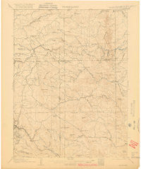
~ Blackhawk CO topo map, 1:62500 scale, 15 X 15 Minute, Historical, 1906, updated 1916
Blackhawk, Colorado, USGS topographic map dated 1906.
Includes geographic coordinates (latitude and longitude). This topographic map is suitable for hiking, camping, and exploring, or framing it as a wall map.
Printed on-demand using high resolution imagery, on heavy weight and acid free paper, or alternatively on a variety of synthetic materials.
Topos available on paper, Waterproof, Poly, or Tyvek. Usually shipping rolled, unless combined with other folded maps in one order.
- Product Number: USGS-5358051
- Free digital map download (high-resolution, GeoPDF): Blackhawk, Colorado (file size: 5 MB)
- Map Size: please refer to the dimensions of the GeoPDF map above
- Weight (paper map): ca. 55 grams
- Map Type: POD USGS Topographic Map
- Map Series: HTMC
- Map Verison: Historical
- Cell ID: 51442
- Scan ID: 402320
- Imprint Year: 1916
- Survey Year: 1904
- Datum: Unstated
- Map Projection: Unstated
- Map published by United States Geological Survey
- Map Language: English
- Scanner Resolution: 508 dpi
- Map Cell Name: Black Hawk
- Grid size: 15 X 15 Minute
- Date on map: 1906
- Map Scale: 1:62500
- Geographical region: Colorado, United States
Neighboring Maps:
All neighboring USGS topo maps are available for sale online at a variety of scales.
Spatial coverage:
Topo map Blackhawk, Colorado, covers the geographical area associated the following places:
- Black Hawk - Eldorado Springs - Tungsten (historical) - Copperdale - Miramonte - Pactolus - Smith Hill - Whispering Pine - Wondervu - Lake Shore Park - Twin Spruce - Saint Ann Highlands - Ridgewood - Magnolia - Coal Creek - Plainview - Crescent - Lincoln Hills - Cottonwood - Pinecliffe - Aspen Meadows - Bonanza Mountain Estates - Crescent Village
- Map Area ID: AREA4039.75-105.5-105.25
- Northwest corner Lat/Long code: USGSNW40-105.5
- Northeast corner Lat/Long code: USGSNE40-105.25
- Southwest corner Lat/Long code: USGSSW39.75-105.5
- Southeast corner Lat/Long code: USGSSE39.75-105.25
- Northern map edge Latitude: 40
- Southern map edge Latitude: 39.75
- Western map edge Longitude: -105.5
- Eastern map edge Longitude: -105.25


