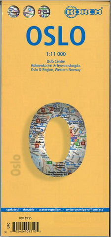
Oslo City Map
Laminated and waterproof map for visitors to Oslo, combining a street plan of the city with maps of the Holmenkollen - Tryvannshøgda area, the Oslo region, and a large part of southern Norway including Stavanger and Bergen.
The street plan at 1:11,000 covers the city’s central districts including the Bygdøy peninsula. A separate inset covers the recreational area of Holmenkollen - Tryvannshøgda area in northern Oslo. Both plans show the metro stations, one way streets and car parks, selected accommodation, places of interest, etc. A panel with top 30 sights lists Oslo’s main places of interest, all highlighted on the plans. Also provided is a large, easy-to-read diagram of the city’s metro network.
On the reverse are two road maps: Oslo and its environs at 1:200,000, plus a large part of central Norway at 1:800,000 stretching from Stavanger in the south across the Hardangervidda National Park to the Jotunheimen and Jostedalbreen National Parks. The maps highlight variou
- Product Number: BOR_OSLO_23
- Reference Product Number: - None -
- ISBN: 9783866093102
- Date of Publication: 6/15/2023
- Folded Size: 9.45 inches high by 4.33 inches wide
- Unfolded (flat) Size: 38.58 inches high by 19.29 inches wide
- Map format: Folded
- Map type: Trade Maps - City Maps
- Geographical region: Norway