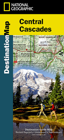


Cascades, Central DestinationMap by National Geographic Maps
• Waterproof • Tear-Resistant • Travel Map
National Geographics Central Cascades Destination Map strikes the perfect balance between map and guidebook and is an ideal resource for touring the beauty and grandeur of the Pacific Northwest of Washington and Oregon. From the foothills to the high desert to the mountain communities, for those who choose to linger and those who want to explore, this map covers it all.
Destination Maps combine finely detailed maps with fascinating and practical travel information. The front side features a large-scale map of the Central Cascades, richly layered with recreation information and beautiful photographs showcasing some of many ways travelers can experience the Pacific Northwest. In addition to the easy-to-read map on the front, the reverse side includes location and visitor information for Mount Rainier National Park, Columbia River Gorge National Scenic Area, and Crater Lake National Park. Explore detailed outdoor adventure recommendations for birding and wildlife viewing, hiking and mountain climbing, biking, fishing, and winter activities (including ski resort information).
Key Features:
Inset maps of Mount Rainier National Park, Columbia River Gorge National Scenic Area, and Crater Lake National Park
Colorful photographs featuring the regions enchanting landscape
Indian Reservations, National Forests, State and National Parks, trails, breweries, wineries, and ski areas are clearly marked
Descriptive content highlighting outdoor recreation opportunities, water features, geology, history and cultural points of interest
Every Destination Map is printed on durable synthetic paper, making them waterproof, tear-resistant and tough - capable of withstanding the rigors of any kind of travel.
Map Scale = 1:746,000
- Product Number: 2059785M
- Product Code: NG_DM_CASCADES
- Publisher Product ID: DM01020690
- ISBN: 9781597755122
- Year of Publication: 2013
- Folded Size: 9.45 x 4.33 inches
- Unfolded Size: 32.68 x 24.8 inches
- Map type: Folded Map
- Geographical region: United States