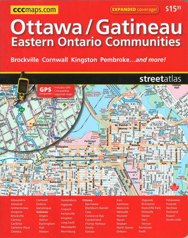
Ottawa Gatineau and Eastern Ontario Communities Street Atlas by Canadian Cartographics Corporation
This GPS Comatible Street guide of Ottawa and area Expanded coverage! now including Eastern Ontario Communities !(Front Cover)/Ottawa/Gatineau Eastern Ontario Communities(Back Cover) Ottawa & Environs Cornwall Kingston Pembroke. This New Atlas features detailed street information for various communities in the Eastern Ontario area including: Alexandria, Almonte, Amherstview,Anprior, Brockville, Cantley, Cardinal, Carleton Place, Chelsea, Cornwall, Embrun, Gananoque, Gatineau, Angers, Aylmer, Buckingham, Hull, Masson, Hawkesbury, Ingleside, Iroquois, Kemptville, Kingston, Long Sault, Montebello, Morrisburg, Ottawa, Barrhaven, Blackburn Hamlet, Carp, Constance Bay,Cumberland, Fitzroy Harbour, Greely, Kanata, Kars, Kenmore, Manotick, Metcalfe, Munster, Navan, Nepean, North Gower, Orleans, Osgoode, Richmond, Rockcliffe Park, Stittsville, Vanier, Vars, Vernon, Pembroke, Perth, Petawawa, Prescott, Renfrew, Rockland, Russell, Smiths Falls ... and much more/et plus!
- Product Number: 2213995
- Product Code: CCC_OTTAWA_AT
- ISBN: 9781553683766
- Year of Publication: 2016
- Unfolded Size: 11.02 x 9.06 inches
- Map type: Atlas
- Geographical region: Ontario