
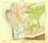
~ La Jolla CA topo map, 1:31680 scale, 7.5 X 7.5 Minute, Historical, 1943
La Jolla, California, USGS topographic map dated 1943.
Includes geographic coordinates (latitude and longitude). This topographic map is suitable for hiking, camping, and exploring, or framing it as a wall map.
Printed on-demand using high resolution imagery, on heavy weight and acid free paper, or alternatively on a variety of synthetic materials.
Topos available on paper, Waterproof, Poly, or Tyvek. Usually shipping rolled, unless combined with other folded maps in one order.
- Product Number: USGS-5657638
- Free digital map download (high-resolution, GeoPDF): La Jolla, California (file size: 11 MB)
- Map Size: please refer to the dimensions of the GeoPDF map above
- Weight (paper map): ca. 55 grams
- Map Type: POD USGS Topographic Map
- Map Series: HTMC
- Map Verison: Historical
- Cell ID: 395995
- Scan ID: 296219
- Woodland Tint: Yes
- Survey Year: 1939
- Datum: NAD27
- Map Projection: Polyconic
- Map published by United States Geological Survey
- Keywords: Overedge
- Map Language: English
- Scanner Resolution: 600 dpi
- Map Cell Name: La Jolla
- Grid size: 7.5 X 7.5 Minute
- Date on map: 1943
- Map Scale: 1:31680
- Geographical region: California, United States
Neighboring Maps:
All neighboring USGS topo maps are available for sale online at a variety of scales.
Spatial coverage:
Topo map La Jolla, California, covers the geographical area associated the following places:
- Riviera Shores - University City - Campland on the Bay Trailer Park - Elvira - Old Town San Diego - Bay Park - Selwyn (historical) - Bayside Village - Linda Vista - Easter Cross - Ladrillo (historical) - North Clairemont - University Heights - Mission Beach - De Anza Trailer Harbor - Serra Mesa - Clairemont - The Muirlands - Pacific Beach - Mission Hills - Morena - Overlook - Fiesta Shores - La Jolla - La Jolla Hermosa - La Jolla Shores
- Map Area ID: AREA32.87532.75-117.2916667-117.125
- Northwest corner Lat/Long code: USGSNW32.875-117.2916667
- Northeast corner Lat/Long code: USGSNE32.875-117.125
- Southwest corner Lat/Long code: USGSSW32.75-117.2916667
- Southeast corner Lat/Long code: USGSSE32.75-117.125
- Northern map edge Latitude: 32.875
- Southern map edge Latitude: 32.75
- Western map edge Longitude: -117.2916667
- Eastern map edge Longitude: -117.125


