
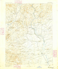
~ Red Bluff CA topo map, 1:250000 scale, 1 X 1 Degree, Historical, 1890
Red Bluff, California, USGS topographic map dated 1890.
Includes geographic coordinates (latitude and longitude). This topographic map is suitable for hiking, camping, and exploring, or framing it as a wall map.
Printed on-demand using high resolution imagery, on heavy weight and acid free paper, or alternatively on a variety of synthetic materials.
Topos available on paper, Waterproof, Poly, or Tyvek. Usually shipping rolled, unless combined with other folded maps in one order.
- Product Number: USGS-5618488
- Free digital map download (high-resolution, GeoPDF): Red Bluff, California (file size: 7 MB)
- Map Size: please refer to the dimensions of the GeoPDF map above
- Weight (paper map): ca. 55 grams
- Map Type: POD USGS Topographic Map
- Map Series: HTMC
- Map Verison: Historical
- Cell ID: 322284
- Scan ID: 299843
- Survey Year: 1884
- Datum: Unstated
- Map Projection: Unstated
- Map published by United States Geological Survey
- Map Language: English
- Scanner Resolution: 600 dpi
- Map Cell Name: Redding E
- Grid size: 1 X 1 Degree
- Date on map: 1890
- Map Scale: 1:250000
- Geographical region: California, United States
Neighboring Maps:
All neighboring USGS topo maps are available for sale online at a variety of scales.
Spatial coverage:
Topo map Red Bluff, California, covers the geographical area associated the following places:
- McColl - Lazy Landing Mobile Home Park - Point McCloud - Ydaloom (historical) - Northgate Trailer Park - Shasta - Mabel (historical) - Shady Hill Trailer Park - Palo Cedro - Matheson - McCartney Place - Lakeshore - Platina - Pinewood Cove - Keswick Dam Trailer Park - Watson - Lewiston - Sugarloaf - Government Camp - Lowrey - Balls Ferry Fishing Resort - Bragdon (historical) - Wonderland Mobile Home Park - Hooker - Coram - Enterprise Mobile Park - Houston (historical) - Copple Place - Redding Lakeside Mobile Estates - Pacheco - Leonard Place (historical) - Cloverdale - Redding - Shasta Lake Mobile Home Park - Las Flores - Swain Place - Cold Fork - Cottonwood Estates - Cedar Stock - Waugh (historical) - Bayha (historical) - Motion - Los Molinos - Riverland Mobile Home Park - Twin View Terrace Mobile Home Park - Marina Travel Park - O'Brien - Summit City (historical) - Holiday Harbor Resort - Dairyville - Bella Vista - Girvan - Los Robles Estates - Shasta Lake - Trinity Center - Vollmers - Lamoine - Project City (historical) - Deadwood - Keswick - Riviera Mobile Estates - Delta - Antlers - Bend - Whiskeytown - Bully Hill - Portal Inn - Redding Oaks Mobile Home Park - Anderson - Pete Hoff Place - Hart (historical) - Kelly (historical) - Baird (historical) - Country Aire Mobile Home Park - Lakehead - Buckeye - Kennett (historical) - Fairview - Pollock - Igo - Park Villa Mobile Home Estates - Mountain Shadows Mobile Home Estates - Wilkinson - Fowler Place - Brown Place - Proberta - Sherman - Elmore (historical) - Cottonwood - River Park Mobile Estates - Henryford (historical) - Skinner Mill Place - Minersville (historical) - Furnaceville (historical) - Mountain Gate Mobile Home Park - Moose-horn Mobile Home Park - Fitzpatrick (historical) - Shackleford Place - Gerber - El Rio Estates
- Map Area ID: AREA4140-123-122
- Northwest corner Lat/Long code: USGSNW41-123
- Northeast corner Lat/Long code: USGSNE41-122
- Southwest corner Lat/Long code: USGSSW40-123
- Southeast corner Lat/Long code: USGSSE40-122
- Northern map edge Latitude: 41
- Southern map edge Latitude: 40
- Western map edge Longitude: -123
- Eastern map edge Longitude: -122


