
~ El Centro CA topo map, 1:250000 scale, 1 X 2 Degree, Historical, 1958, updated 1972
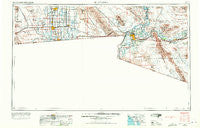
El Centro, California, USGS topographic map dated 1958.
Includes geographic coordinates (latitude and longitude). This topographic map is suitable for hiking, camping, and exploring, or framing it as a wall map.
Printed on-demand using high resolution imagery, on heavy weight and acid free paper, or alternatively on a variety of synthetic materials.
Topos available on paper, Waterproof, Poly, or Tyvek. Usually shipping rolled, unless combined with other folded maps in one order.
- Product Number: USGS-5506543
- Free digital map download (high-resolution, GeoPDF): El Centro, California (file size: 12 MB)
- Map Size: please refer to the dimensions of the GeoPDF map above
- Weight (paper map): ca. 55 grams
- Map Type: POD USGS Topographic Map
- Map Series: HTMC
- Map Verison: Historical
- Cell ID: 74959
- Scan ID: 299763
- Imprint Year: 1972
- Woodland Tint: Yes
- Aerial Photo Year: 1955
- Edit Year: 1969
- Field Check Year: 1958
- Datum: Unstated
- Map Projection: Transverse Mercator
- Map published by United States Geological Survey
- Map published by: Military, Other
- Map Language: English
- Scanner Resolution: 600 dpi
- Map Cell Name: El Centro
- Grid size: 1 X 2 Degree
- Date on map: 1958
- Map Scale: 1:250000
- Geographical region: California, United States
Neighboring Maps:
All neighboring USGS topo maps are available for sale online at a variety of scales.
Spatial coverage:
Topo map El Centro, California, covers the geographical area associated the following places:
- Imperial - Citrus View - Dunes West Mobile Home Park - Ruthven - Date City - Clyde - Plaster City - San Luis - El Centro - Laguna Mobile Home Park - Mount Signal - Castle Dome Landing - Westward Village Mobile Park - Dixieland - Steam - Fuller - Bard - Chaparral Mobile Home Park - Ross Corner - Rancho Rialto Mobile Home Park - Felicity - Sandia - Sunset Mobile Home Park - Sunny Acres Mobile Park - Alamorio - Fishers Landing - Ocotillo - Yuma Indian Homesteads - Watermans Corner - Anza - Moss - Desert Royal Mobile Park - Noah - Country Breeze Mobile Home Park - Wilsie - Desert Lakes Mobile Home Subdivision - Araz Junction - Asher - Heber - Kool Corner - Capri Mobile Park - Palm Garden Estates Mobile Home Park - Sun Vista Resort Mobile Home Park - Calexico - Perrys Corner - Winterhaven - Coyote Wells - Brawley - Obregon - Yuma - Ogilby - Melody Mobile Court - Sierra Pacific Mobile Home Park - Orita - Laguna - Dunes - Mesa Terrace Mobile Estates - Fortuna - Rico - Seeley - Blaisdell - Friendly Acres Mobile Home Park - Meloland - Cactus - Shangri - La Mobile Home Park - Ligurta - Curlew - Holtville - Sunrise Mobile Home Estates - Edgar - Glamis - San Dionysio (historical) - Bonds Corner - Dome - Araby - Kinter - Araby Acres Mobile Home Park - Wellton - Desert Palms Mobile Estates - Gadsden - Town and Country Mobile Home Park - Fortuna Foothills - Somerton
- Map Area ID: AREA3332-116-114
- Northwest corner Lat/Long code: USGSNW33-116
- Northeast corner Lat/Long code: USGSNE33-114
- Southwest corner Lat/Long code: USGSSW32-116
- Southeast corner Lat/Long code: USGSSE32-114
- Northern map edge Latitude: 33
- Southern map edge Latitude: 32
- Western map edge Longitude: -116
- Eastern map edge Longitude: -114


