
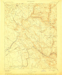
~ Sonora CA topo map, 1:125000 scale, 30 X 30 Minute, Historical, 1897, updated 1912
Sonora, California, USGS topographic map dated 1897.
Includes geographic coordinates (latitude and longitude). This topographic map is suitable for hiking, camping, and exploring, or framing it as a wall map.
Printed on-demand using high resolution imagery, on heavy weight and acid free paper, or alternatively on a variety of synthetic materials.
Topos available on paper, Waterproof, Poly, or Tyvek. Usually shipping rolled, unless combined with other folded maps in one order.
- Product Number: USGS-5506353
- Free digital map download (high-resolution, GeoPDF): Sonora, California (file size: 7 MB)
- Map Size: please refer to the dimensions of the GeoPDF map above
- Weight (paper map): ca. 55 grams
- Map Type: POD USGS Topographic Map
- Map Series: HTMC
- Map Verison: Historical
- Cell ID: 66660
- Scan ID: 299656
- Imprint Year: 1912
- Survey Year: 1891
- Datum: Unstated
- Map Projection: Unstated
- Map published by United States Geological Survey
- Map Language: English
- Scanner Resolution: 600 dpi
- Map Cell Name: Sonora
- Grid size: 30 X 30 Minute
- Date on map: 1897
- Map Scale: 1:125000
- Geographical region: California, United States
Neighboring Maps:
All neighboring USGS topo maps are available for sale online at a variety of scales.
Spatial coverage:
Topo map Sonora, California, covers the geographical area associated the following places:
- Cherokee - Yosemite Junction - Quartz - Diamond Bar B Ranch - Peppermint Creek - Sonora - Dogtown - Bagby - Tuttletown - Gibbs Ranch - Montezuma - Quail Hollow - Rawhide - East Sonora - Cuesta Serena - Greeley Hill - Monte Grande Heights - Sonora Knolls - Oak Gardens Estates - Buckhorn Estates - Rancho Poquitos - Blanchard - Fairway Acres - Bear Valley - Curtis Creek Ranch - Hayward - Buck Meadows - Standard - Greenley Oaks - Tuolumne - Granite Springs - Sunshine Camp - Tuolumne City - Peaceful Valley - Barrett - Jamestown - Rancho Sonora Estates - Coulterville - Groveland - Big Oak Flat - Heavenly Hills - Snelling - Sonora Ranchettes - Priest - Woods Crossing - Moccasin - Mount Bullion - Lambert Lake Estates - Algerine - Volponi Acres - Scenic Brook - Chinese Camp - Buchanan - Arastraville - Rolling Hills - Merced Falls - Femmons - Willow Springs - Ralph - Colfax Spring - Scenic View - Melones Sunset Lake Estates - Sonora Hills - Newtown (historical) - Campo Seco - Mono Vista - Stent - Mother Lode West - Mono Village - Soulsbyville - Quail Ridge Ranch - La Grange - Second Garrotte - Hornitos - Hetch Hetchy Junction
- Map Area ID: AREA3837.5-120.5-120
- Northwest corner Lat/Long code: USGSNW38-120.5
- Northeast corner Lat/Long code: USGSNE38-120
- Southwest corner Lat/Long code: USGSSW37.5-120.5
- Southeast corner Lat/Long code: USGSSE37.5-120
- Northern map edge Latitude: 38
- Southern map edge Latitude: 37.5
- Western map edge Longitude: -120.5
- Eastern map edge Longitude: -120


